Characteristics of the geographical shell of the earth. Geographical envelope, its properties and integrity What are the main features of the geographical envelope
The geographic envelope is a complete and continuous shell of the Earth, formed as a result of the interpenetration and interaction of substances of individual geospheres - the lithosphere, hydrosphere, atmosphere and biosphere. Its boundaries are unclear, so scientists define them differently. The upper boundary is taken to be the ozone screen at an altitude of 25-30 km, the lower boundary is taken within the lithosphere at a depth of several hundred meters, sometimes up to 4-5 km or along the ocean floor. It consists entirely of the hydrosphere and biosphere, most of the atmosphere and part of the lithosphere. The geographic envelope constitutes a complex dynamic system, which is characterized by the presence of substances in three states of aggregation - solid, liquid and gaseous, an oxidizing environment and living matter, complex migration of matter with the participation of water, oxygen and living organisms, concentration of solar energy and a wealth of various types of free energy .
The geographical envelope covers the entire planet, therefore it is considered a planetary complex. It is here that all the shells come into close contact and interpenetrate and life is focused. The geographical shell contains a living human society; it has a number of specific features. It is distinguished by a wide variety of composition and types of energy. The geographical envelope is heterogeneous not only in the vertical, but also in the horizontal directions. It differentiates into separate natural complexes - relatively homogeneous parts of the Earth's surface. Its differentiation into natural complexes is due to the uneven supply of heat to its different parts and the heterogeneity of the earth's surface.
Zonal features of the geographical envelope
The geographic envelope has a number of regularities. The most important of them are: integrity, rhythm of development, horizontal zoning and altitudinal zonation. Integrity is the unity of the geographical shell, due to the interconnectedness of its components. A change in one of the components certainly entails a change in the others. Thus, forests lead to a whole chain of natural changes: forest plants and animals disappear - soils are destroyed and washed away - groundwater levels decrease - rivers become shallow. Integrity is achieved by the circulation of matter and energy (atmospheric circulation, system of sea currents, water cycle, biological cycle). They ensure repeatability of processes and phenomena and promote relationships between natural components.
Due to the rotation of the Earth around its axis and the Sun, uneven heating of the earth's surface, all processes and phenomena in the geographic envelope are repeated after a certain period of time. This is how rhythmicity arises - the natural repetition of natural phenomena and processes over time. There are daily and seasonal rhythms, for example, the changes of day and night, seasons, ebb and flow, and the like. There are rhythms that repeat after a certain period of time: windows of climate fluctuations and water levels in lakes and the like.
Zoning is a natural change in natural components and natural complexes in the direction from the equator to the poles. It is caused by different amounts of heat due to the sphericity of the Earth. Zonal complexes include geographic zones and natural zones. Geographical belts are the most zonal complexes, extending in the latitudinal direction (equatorial, subequatorial, tropical, etc.). Each geographical zone is divided into smaller complexes of natural zones (steppes, deserts, semi-deserts, forests).
Altitudinal zonation is a natural change in natural components and natural complexes with an ascent into the mountains from their foot to the peaks. It is caused by climate change with altitude: a decrease in temperature (by 0.6 ° C for every 100 m of rise) and up to a certain altitude (up to 2-3 km) an increase in precipitation. Altitudinal zonation has the same sequence as on the plain when moving from the equator to the poles. However, natural zones in the mountains change much faster than natural zones on the plains. In addition, in the mountains there is a special belt of subalpine and alpine meadows, which is not found on the plains. The number of altitudinal zones that begin with an analogue of the horizontal zone within which the mountains are located depends on the height of the mountains and location.
Identification of the most important qualitative properties and features of the nature of the geographical envelope is an indispensable condition for understanding the basic patterns of its differentiation.
I As already noted, the geographical shell is a complex, historically established and continuously developing, holistic and qualitatively unique material system. It has the following important features:
1) - its qualitative originality, which lies in the fact that only within its limits a substance is simultaneously in three physical states: solid, liquid and gaseous. In this connection, the geographical envelope consists of five qualitatively different, interpenetrating and interacting geospheres: lithosphere, hydrosphere, atmosphere, biosphere and paleosphere. Within each of them there are several components. For example, within the lithosphere, various rocks are distinguished as independent components, in the biosphere - plants and animals, etc.
2) - close interaction and interdependence of all its geospheres and parts, determining its development. The experience of mankind has shown that the geographical envelope is not a conglomerate of various objects and phenomena independent of each other, but a complex complex, a natural system that represents a single whole. It is enough to change only one link of this integral system to cause changes in all its other parts and in the complex as a whole. Human society, transforming nature for the purpose of more rational use of natural resources, must take into account all possible consequences of impact on individual parts of this system and prevent unwanted changes in it. Thus, burning forests on the slopes of the mountains of Cuba and obtaining fertilizer from the ash from the fire for just one generation of very profitable coffee trees, the Spanish planters did not care that tropical rains subsequently washed away the already defenseless top layer of soil, leaving behind only bare rocks ( Yurenkov, 1982). In all cases, when it comes to influencing some parts of natural systems on a large scale, a reasonable approach should prevail. For example, put forward in the 80s. 20th century and the project for the creation of the Nizhneob hydro complex, which was not approved by the State Planning Committee of the former USSR, provided for obtaining very cheap and large quantities of much-needed energy for Siberia. But as a result of the construction of a dam in the lower reaches of the Ob River, a vast sea would have formed in the form of a flooding zone, which would have been frozen for about nine months of the year. This, in turn, would significantly change the climate of adjacent territories and would have an undesirable effect on agriculture, industry, and human health. Mineral resources (oil, gas, etc.), millions of hectares of agricultural land, and forests, which (among other things) are the most important producers of oxygen, would be flooded. Ready-made diploma robots are quick and inexpensive; all this can be found on the website zaochnik.ru. Also here you can order a practice report, essay, semester work, dissertation.
One of the most important manifestations of the interaction of all geospheres and components of the geographical shell is the constant exchange of matter and energy, therefore all sides and components of the geographical shell, consisting mainly of a certain, unique combination of chemical substances, as a rule, also include a certain amount of substances , constituting the bulk of the remaining components or being derivatives of this bulk (A.A. Grigoriev, 1952, 1966). The interaction of all sides, components and parts of the geographical shell, their internal contradictions is the main reason for its constant development, complexity, transition from one stage to another.
3) - this integral material system is not isolated from the outside world, it is in constant interaction with it. The outer world for the geographic shell is, on the one hand, Space, and on the other, the inner spheres of the globe (the mantle and the earth’s core).
Interaction with Space is manifested primarily in the penetration and transformation of solar energy within the geographic envelope, as well as in heat radiation from the latter. The main source of heat for the geographic envelope is solar radiation - 351 10 22 J/year. The amount of heat received due to processes occurring in the depths of the earth is small - about 79x10 19 J/year (Ryabchikov, 1972), i.e. 4400 times less.
Along with solar and other cosmic energy, interstellar matter continuously enters the Earth in the form of meteorites and meteor dust (up to 10 million tons/year; Yurenkov, 1982). At the same time, our planet is constantly losing light gases (hydrogen, helium), which, rising into the high layers of the atmosphere, escape into interplanetary space. This interchange of chemical elements between the Earth and Space was substantiated by V.I. Vernadsky. Iron, magnesium, sulfur and other elements migrate from the earth's crust to the deeper spheres of the Earth, and silicon, calcium, potassium, sodium, aluminum, radioactive and other elements come from the deep spheres.
The interaction of the geographical shell with the internal spheres of the Earth is also manifested in a complex energy exchange, which determines the so-called azonal processes, and first of all, the movements of the earth’s crust. Contradictory, unified and inextricable zonal and azonal processes determine the most important regularity of the geographical envelope - its zonal-provincial differentiation.
4) - in the geographical shell, both the emergence of new forms and the disintegration of more complex formations occurs, i.e. one of the basic laws of nature is implemented - the law of synthesis and decay and their unity (Gozhev, 1963), which contributes to the constant development and complication of the geographical shell, its transition from one stage to another.
The development of the geographical envelope is characterized by rhythm and progression, that is, a transition from simpler to more complex; constant complication of its zonality and provinciality, the structure of its natural systems.
The development of the geographic envelope and its parts is subject to the “law of heterochronic development” (Kalesnik, 1970), which manifests itself in the non-simultaneous changes in the nature of the geographic envelope from place to place. For example, noted in the 20-30s of the twentieth century. In the northern hemisphere, the “Arctic warming” on Earth was not widespread, and at the same time, cooling was observed in some areas of the Southern Hemisphere.
A characteristic feature of the development of the geographic envelope is the increasing relative conservatism of natural conditions as one moves from higher to lower latitudes. The age of natural zones is also increasing in the same direction. Thus, the tundra zone has the youngest, post-glacial age; in the Pliocene-Quaternary, the forest zone mainly took shape; in the Pliocene - forest-steppe, in the Oligocene-Pliocene - steppe and desert.
5) - characterized by the presence of organic life, with the emergence of which all other geospheres (atmosphere, hydrosphere, lithosphere) underwent profound changes.
6) - it is the arena of life and activity of human society. At the current stage, a reasonable person is an indicator of the highest stage of development of the geographical envelope.
7) - it is characterized by regional differentiation. According to materialist dialectics, the unity of the world does not exclude its qualitative diversity. The integral geographical envelope is heterogeneous from place to place and has a complex structure. On the one hand, the geographical envelope has continuity (all its sides, components and structural parts are connected and permeated by the flow of matter and energy; it is characterized by continuity of distribution), on the other hand, it is characterized by discreteness (the presence of natural-territorial complexes - NTC) inside this continuous envelope , possessing relative integrity.) Moreover, continuity is generally manifested stronger than discontinuity, i.e. the geographical shell is a single whole, a solid body, and its discontinuity is conditional, since the PTC are its constituent parts, between which there are no voids or formations alien to the geographical shell (Armand D. et al., 1969).
Qualitative differences in the interactions between the parties and components of the geographical envelope in its different places, and at the same time its regional differentiation, are primarily determined by the unequal ratios of the quantitative indicators of these parties and components of nature. Thus, even the same amount of precipitation for different territories with different ratios of quantitative indicators of other components of nature predetermines the difference in the degree of moisture in these territories with all the ensuing consequences. Thus, with approximately equal amounts of precipitation in the northern regions of Russia and in the north of the Central Asian plains (200-300 mm/year), but significantly different values of solar radiation, different conditions of the atmosphere, unequal temperature conditions, in the first case there is a lack of heat and excess moisture and tundra landscapes are formed, in the second - with an abundance of heat and lack of moisture - semi-desert landscapes are formed.
The dialectical unity of the properties of continuity and discreteness of the geographical shell allows us to distinguish among the objects studied by physical geography relatively independent natural-territorial complexes (NTCs) of different ranks - complex geographical systems (geosystems).
Natural-territorial complexes are understood as areas of the geographic envelope that have natural boundaries that are qualitatively different from other areas and represent an integral and natural set of objects and phenomena. The order of magnitude and degree of complexity of PTCs are very diverse. The simplest internal organization is found in small-area PTCs (PTCs of a riverbed bank, the slope of a moraine hill, the side of a ravine, etc.). With increasing rank, the degree of complexity and the area of the PTC increase, since they already include systems of many PTCs of lower rank. As an example of such PTCs, we can note the Eastern European province of the taiga zone, the taiga zone as a whole, etc.
PTCs include all or most of the main components of nature - the lithogenic base, air, water, soil, vegetation, and fauna. They are structural elements of the geographical shell.
Some physical geographers (K.V. Pashkang, I.V. Vasilyeva et al., 1973) divide all natural complexes into complete (called natural-territorial and consist of all components of nature) and incomplete and consist of one (single-member natural complexes ) or several (of two - two-membered, of three - three-membered natural complexes) components of nature. According to the views of these authors, “natural-territorial complexes are the main object of study of physical geography,” and single-member (phytocenosis, air mass, etc.), two-member (for example, a biocenosis consisting of interconnected phyto- and zoocenosis) natural complexes are the subject of study of the corresponding branches of natural science: phytocenoses are studied by geobotany, air masses by dynamic meteorology, biocenoses by biocenology. This interpretation of the issue raises significant objections. Firstly, it is necessary to clarify that PTC as a whole are the main object of study not of physical geography in general, but of regional physical geography and landscape science. Secondly, the legality of isolating so-called incomplete natural complexes is very doubtful. Obviously, it is not logical to call natural formations consisting of one component of nature a natural complex, even a single-member one. Most likely this is part of a natural complex. Thus, the accumulation of coarse clastic material does not represent a natural complex, even a single-member one. The phytocenosis and biocenosis cited as examples do not exist in nature as “incomplete” natural complexes. There are no plant communities in nature that are not in close relationship with the other components of nature - the lithogenic base, air, water, and fauna. This is one of the manifestations of the most important law of materialist dialectics—the law of the unity of the organism and its living conditions. And if a geobotanist or biocenologist, due to the tasks facing him, does not seek to reveal these relationships, this does not mean at all that these relationships do not exist, and does not give any reason to call phytocenoses and biocenoses incomplete natural complexes.
The inappropriateness of classifying a phytocenosis as a single-member natural complex is obvious already because a biocenologist can consider the same territory as a two-member one, and a landscape scientist as a complete natural complex consisting of all the components of nature. The above applies equally to other “incomplete” complexes.
All natural complexes at this stage of their development are complete. This already follows from the most important regularity of the geographical shell - the interaction and interdependence of all its geospheres, components and structural parts. There is not a single component of the geographic envelope that does not experience the influence of others and does not influence them. This interaction occurs through the exchange of matter and energy.
The most important features by which one PTC differs from another are: their relative genetic heterogeneity; qualitative differences, which are primarily determined by the different quantitative characteristics of their constituent components; a different natural set of components and the conjugacy of the structural parts of the compared PTCs.
§ 10.1. Basic properties of the geographic shell
Geographical envelope and its features
The study of the interaction between nature and society is one of the pressing problems of modern natural science. It is advisable to begin its analysis by considering the geographical envelope, where very complex processes take place, and the interaction of flows of matter and energy occurs.
The geographic envelope of the Earth, including the earth's crust (lithosphere), lower layers of the atmosphere, hydrosphere and the entire biosphere, is an integral, self-developing complex system that is in relatively fluid equilibrium. All components of the geographic envelope and the processes occurring in it are closely related and interdependent. Moreover, its individual components are influenced by all other components. This often completely changes the original properties of the entire interacting system.
Usually the average thickness of the geographic shell is estimated at 50-60 km. Its upper boundary is located in the atmosphere - in the tropopause, i.e. transition layer from the troposphere to the stratosphere (see Fig. 8.3), at an altitude of 8-10 km in subpolar latitudes, 10-12 km in temperate latitudes, 15-16 km in tropical latitudes and 17 km above the equator. The lower boundary of the geographic shell is within the earth's crust. There is no consensus on its position. Some researchers believe that it should be carried out in the region of that part of the earth's crust where the speed of propagation of longitudinal and transverse elastic waves changes abruptly (Moho boundary). Other scientists attribute it to the higher parts of the earth's crust - to the area in which chemical and physical transformations of mineral substances occur under the influence of the atmosphere, hydrosphere and living organisms (the so-called hypergenesis zone). These processes extend to depths from several tens to several hundred meters.
The geographical shell is “embedded” in a broader formation - in a geographical space that has a direct impact on it. From the outside, geographic space asymmetrically covers the Earth - it is elongated in the direction opposite to the Sun (Fig. 10.1). The outer limit of geographic space is the boundary of the Earth's magnetic field - the magnetosphere, which protects the geographic envelope from the action of the solar wind - a flow of charged plasma (ionized gas) and particles of cosmic (extrasolar) origin. These particles are directed by magnetic lines of the magnetosphere to the geomagnetic poles of the Earth and, partially penetrating the geographic envelope, have a significant impact on the development of living organisms. Ultraviolet radiation is intercepted by the ozone layer, which serves as an internal protection of the geographical envelope and its living organisms. Long-wave radiation (rays of light), freely penetrating into the geographic envelope, ensures photosynthesis and, consequently, the supply of oxygen to the atmosphere and ocean.
The geographic envelope is also based on geographic space on the side of the lower boundary (i.e., geographic space is also located below the Moho boundary). Its influence is manifested in the fact that the energy of the earth's interior created (and is creating) unevenness of the earth's surface, including continents and oceanic depressions, the lithosphere, which is part of the geographic shell with its outer part. At the same time, chloride brines, which determine the chemistry of the ocean, etc., enter the geographic shell from the earth’s interior.
Closely related to the concept of “geographical envelope” is the idea of biosphere - one of the shells of the Earth that arose during the evolution of the planet and is characterized by the presence of life. Initially, the term was used to designate one of the geospheres that are part of the geographical envelope, along with the atmosphere, lithosphere, hydrosphere, but differing from them in the saturation of living organisms and the products of their vital activity. Thanks to the works of V.I. Vernadsky, who revealed the enormous role of living organisms in the creation of the gas composition of the atmosphere, the formation of sedimentary rocks, waters of the Earth, etc., under the biosphere began to be understood as the entire outer region of planet Earth in which not only life exists, but which is to one degree or another modified or shaped by life. The emergence of the biosphere is an important stage in the development of the geographical envelope, preceding the formation of the noosphere (sphere of the mind).
As a result of the active circulation of matter and energy on the surface of the land, in the place of direct contact of the layer of life and the lithosphere, which is the focus of interaction between living and inert matter, a peculiar bioinert formation - soil, participating in the biological cycle of elements of the lithosphere - vegetation system. The founder of genetic soil science V.V. Dokuchaev figuratively called the soil a mirror of the landscape. Indeed, soil is a fairly sensitive indicator of processes occurring in the geographic environment. The root system of plants absorbs water and mineral nutrients from the soil. The exchange of elements between soil and vegetation is facilitated by microorganisms living around the roots. Dead organic matter from the above-ground parts of plants falls onto the soil surface. Part of it, as well as the remains and excrement of animals, are completely mineralized into simple substances, mainly by microorganisms, which can be called “cleaners” of the soil and biosphere from the dead remains of organisms. As a result, the surface soil horizon is enriched with a number of biogenic elements borrowed by vegetation from deeper layers of the soil and atmosphere and necessary for the mineral nutrition of subsequent generations of organisms. The other part of the dead organic matter is not completely mineralized - a complex high-molecular colloidal organic substance of brown or black color is synthesized from it - humus (humus). Humus is highly resistant to decomposition and mineralization, so it gradually accumulates, which leads to the formation of a dark humus horizon on the soil surface (it is present in every soil, and in the hydrosphere - in the bottom silt of reservoirs). Despite its great stability, humus still undergoes slow decomposition. Therefore, it serves as a constant source of substances and energy easily accessible to organisms and plays an exceptional role in creating soil fertility. Humus is a reserve and stabilizer of organic life in the biosphere.
The processes of biogenic accumulation in the soil are combined with processes characteristic of the weathering crust, as a result of which the initially homogeneous thickness of the soil-forming rock is divided into horizons. A soil profile is formed - a characteristic feature of the soil, first identified by the founder of soil science V.V. Dokuchaev. The processes occurring in the soil determine to a significant extent the transformations occurring in the subsoil horizons of the weathering crust. In soils, the basic material is prepared, which subsequently forms continental and marine sediments, from which new rocks are formed. Moreover, due to the removal from the soil and, in general, from the weathering crust of elements that are easily mobile in the aquatic environment, a significant part of the salts of the hydrosphere was formed.
Energy sources of existence of the geographical shell
The geographical shell owes its existence to various types of energy:
◊ the main primary types of energy are the radiant energy of the Sun and the internal heat of the Earth;
◊ secondary types of energy, resulting from the transformation of primary ones - chemical energy, manifested mainly in the form of redox processes, and biogenic energy, the source of which is photosynthesis in plants, chemosynthesis in some bacteria, oxidation energy during the assimilation of food by animals, processes of reproduction and biomass growth ;
◊ technogenic energy, i.e. energy created by human society in the production process, which is comparable in magnitude to natural factors.
Solar radiation is the main engine of all natural processes in the geographic environment. It is thanks to it that rivers flow, winds blow, fields turn green... Solar radiation provides 99.8% of all heat that reaches the surface of the Earth. Only 28% of the total flux of solar radiation arriving at the upper boundary of the atmosphere determines the thermal regime of the earth's surface. On average, for the entire surface of the Earth, this influx of solar heat is 72 kcal/cm2 per year. It is spent on melting ice and evaporation of water, on photosynthesis, as well as on heat exchange between the earth's surface, atmosphere and waters and between the surface and the underlying layers of soil. Note that since there is less cloudiness over the land, therefore, less radiation is reflected by the clouds into space and the land receives more solar radiation than the same area of the ocean. But land also has a high reflectivity (albedo): receiving more solar heat than the ocean, land gives off more of it. As a result, the radiation balance of the ocean surface is 82 kcal/cm2 per year, and the land surface is only 49 kcal/cm2 per year.
Approximately 1/3 of the total amount of solar energy arriving at the upper boundary of the atmosphere is reflected into space, 13% is absorbed by the ozone layer of the stratosphere, and 7% by the rest of the atmosphere. Consequently, only half of the sun's energy reaches the earth's surface. But of this half, 7% is reflected back into space, and another 15%, absorbed by the earth’s surface, is transformed into heat, which is radiated into the troposphere and largely determines the air temperature.
Of the total amount of solar energy arriving on the earth's surface, land and sea vegetation uses an average of about 1% for photosynthesis (in optimal moisture conditions - up to 5%), although photosynthetically active radiation (which can be used for photosynthesis) makes up approximately 50% of the total radiation reaching the Earth's surface. From all this it follows that finding ways to increase the rate of photosynthesis by increasing the amount of solar energy used can lead to a solution to the food problem facing humanity.
The geographic envelope is capable of accumulating the radiant energy of the Sun, converting it into other forms. It is characterized by the presence of the so-called geological memory - layers of sedimentary rocks with enormous energy potential, which creates the preconditions for the further progressive evolution of all particular geoenvelopes. Solar radiation has a significant impact on the development of the lithosphere, since sedimentary rocks bear traces of the activity of organisms - solar energy accumulators, and crystalline rocks, which ended up on its surface as a result of the internal forces of the Earth, are included in the cycle of substances primarily under the influence of solar radiation.
Internal heat of the Earth plays an important role in the life of the geographic envelope, although it is supplied approximately 5 thousand times less than solar heat. The sources of internal heat are:
O decay of radioactive elements (radium, uranium, thorium, etc.). Their relative content in the earth's crust is small, but the absolute amount is measured in hundreds of millions of tons. Atoms of radioactive elements decay spontaneously, releasing heat. It accumulated from the moment the Earth appeared and largely determined its heating. Thus, 1 g of radium produces 140 calories per hour, and with a half-life that lasts approximately 20 thousand years, it releases the same amount of heat as when burning 500 kg of coal. The total thermal energy of radioactive decay is estimated at 43,1016 kcal/year;
◊ gravitational differentiation with redistribution of material by density (compaction) in the mantle and core, accompanied by the release of heat. Particles that were loosely “packed” during the formation of our planet, moving towards its center, convert potential energy into kinetic and thermal energy.
Within the geographic envelope, the effect of gravity intensifies, since matter here exists in different states of aggregation (solid, liquid and gaseous). Therefore, tectonic processes of movement of the earth's crust are most clearly manifested at the border of different spheres - the lithosphere and atmosphere, lithosphere and hydrosphere. If in the lithosphere pressure increases uniformly on average by 275 atm per 1 cm2 per 1 km depth, then in the ocean it increases three times slower, and the air pressure in the atmosphere is negligible compared to the lithosphere and hydrosphere. The forces of deep energy cause horizontal movements of lithospheric plates, the rise and fall of continents, the retreat and advance of seas. The inner life of the Earth manifests itself in the form of earthquakes and volcanic eruptions, as well as geysers (springs that periodically emit fountains of hot water and steam).
The exchange of matter and energy is most intense in the landscape-forming layer of the geographic envelope. The thickness of this layer is estimated to range from 30-50 m in polar deserts to 150-200 m in the zone of tropical rainforests (gyl); in the ocean it includes the entire thickness of the hydrosphere. The landscape-forming layer is characterized by the closest direct contact of all components of the geographical envelope under the influence of the energy of the Sun, the internal forces of the Earth (including gravity) and human activity.
Geographic shell structure
One of the important features of the geographical envelope is its geographical zoning. Ideas about it appeared in ancient Greece. The concept of geographic zoning was substantiated by V.V. Dokuchaev in 1899
The uneven distribution of solar radiation over the Earth's surface leads to the emergence of climatic zones, each of which is characterized by certain natural processes. Based on them, they distinguish geographical zones.
Usually they talk about 13 geographical zones: one equatorial, two subequatorial (in the Northern and Southern Hemispheres), two tropical, two subtropical, two temperate, two subpolar (subarctic and subantarctic) and two polar (Arctic and Antarctic). Even the list of names itself indicates the symmetrical arrangement of the belts in relation to the equator. Each of them is dominated by certain air masses. The equatorial, tropical, temperate, and arctic zones are characterized by their own air masses, while the remaining zones are alternately dominated by the air masses of neighboring geographic zones. In the summer half of the year in the Northern Hemisphere, air masses from the more southern zone dominate (and in the Southern, on the contrary, from the more northern), in the winter half of the year - from the more northern zone (and in the Southern Hemisphere - from the more southern).
The latitudinal geographical zones of land are heterogeneous, which is determined primarily by the region in which they are located - oceanic or continental. Oceanic regions are better moistened, while continental, inland regions, on the contrary, are drier, since here the influence of the oceans is almost not felt. On this basis, belts are divided into oceanic and continental. sectors.
The sectorality is most clearly expressed in the temperate and subtropical zones of Eurasia - a continent of maximum size. Here, the wet forest landscapes of the oceanic margins, as you move inland, are replaced by dry steppe, and then semi-desert and desert landscapes of the continental sector. The sectorality is less clearly visible in the tropical, subequatorial and equatorial zones. In the tropics there are only two sectors. Trade winds (air currents stable throughout the year over the oceans) bring precipitation only to the eastern outskirts of the belts, where tropical rainforests are common. The inland and western regions have a dry, hot climate; on the western coasts the deserts extend right to the ocean. Two sectors are also distinguished in the equatorial and subequatorial belts. In the subequatorial region, it is constantly wet (eastern) with forest landscapes and seasonally wet (includes the rest of the region), occupied by woodlands and savannas. In the equatorial belt, most of the territory belongs to the constantly wet sector with wet “rain” forests, and only the eastern periphery belongs to the seasonally wet sector, where predominantly deciduous forests are common. The sharpest “sector boundary” occurs where mountain barriers stand in the way of air masses (for example, the Cordillera in North America and the Andes in South America). Here, the western oceanic sectors are limited by a narrow coastal strip of plains and adjacent mountain slopes.
Sectors are subdivided into smaller units - natural areas, differing in the ratio of heat and moisture, since the same amount of precipitation, for example less than 150-200 mm per year, in the tundra can lead to the development of swamps, and in the tropics - to the formation of deserts.
If the division of continents into belts is based primarily on differences in radiation conditions on the earth's surface, then the division into zones is based on differences in the radiation balance and annual precipitation, i.e. moistening the earth's surface. The ratio of heat and moisture is expressed by the formula radiation dryness index:
IR = R /(Lr\
Where R-
annual surface radiation balance, i.e. arrival - consumption of radiant energy of solar radiation, kcal/cm2; L-
annual latent heat of evaporation, kcal/cm; G - annual precipitation, g/cm2. Radiation balance R land surface decreases from the equator to the poles: at the equator it is about 100 kcal/cm2 per year, in the St. Petersburg region - 24 kcal/cm2 per year (Fig. 10.2). The dryness index does not fully characterize geographic zones. The same value, as can be seen from the figure, is typical for different natural zones: for the taiga, and for the deciduous forests of the temperate zone, and for the equatorial forests. Therefore, scientists are trying to find more universal characteristics of geographic zonation.
When moving from the poles to the equator on the continents, especially in the Northern Hemisphere, some general properties of nature are periodically repeated: treeless tundra is followed to the south by forest zones of the temperate zone, followed by steppes and deserts of the temperate, subtropical, tropical zones, then forests of the equatorial belts This pattern was reflected in the periodic law of zoning, according to which the basis for differentiation of the geographical envelope is:
◊ the amount of absorbed solar energy, increasing from the poles to the equator and characterized by the annual values of the radiation balance of the earth’s surface; 

◊ the amount of incoming moisture, characterized by annual precipitation amounts;
◊ the ratio of heat and moisture, more precisely, the ratio of the radiation balance to the amount of heat required to evaporate the annual amount of precipitation - the radiation dryness index.
The law of periodicity is manifested in the fact that the values of the dryness index vary in different zones from 0 to 4-5, three times between the poles and the equator they are close to unity - these values correspond to the highest biological productivity of landscapes (Fig. 10.3).
Landscapes - smaller units compared to natural areas serve as the main cells of the geographical envelope. Based on microclimate, microrelief, and soil subtypes, landscapes are divided into tracts and then into facies that differ from the surrounding ones. This could be a specific ravine or hill and its slopes, forest, field, etc.
The location of geographical belts and zones on the earth's land can be understood by referring to a hypothetical homogeneous flat continent with an area equal to the land area. The outline of this continent in the Northern Hemisphere is a cross between North America and Eurasia, and in the Southern Hemisphere it is a cross between South America, Africa and Australia (Fig. 10.4). The boundaries of geographical zones and zones drawn on this hypothetical continent reflect their generalized (average) contours on the plains of real continents. The names of natural zones are given by vegetation, since in the same natural zones on different continents the vegetation cover has similar features. However, the distribution of vegetation is influenced not only by the zonal climate, but also by other factors - the evolution of continents, the characteristics of the rocks that make up the surface horizons, and, of course, human activity. Note that the structure of the belts and the set of natural zones become more complex from the Arctic regions to the equator. In this direction, against the background of an increasing amount of solar radiation under humidifying conditions, regional differences are increasing. This explains the more diverse nature of landscapes in tropical latitudes. In the polar regions, with constant waterlogging but insufficient heat, this is not observed.
In addition to climatic factors, the landscape structure of the geographic envelope is influenced by differences in the structure of the earth's surface. For example, in the mountains, altitudinal (or vertical) zoning is clearly evident, where landscapes change from the foothills to the peaks. The existence of latitudinal (horizontal) and altitudinal zoning allows us to talk about the three-dimensionality of geographic zones. The flora and fauna of mountain landscapes developed simultaneously with the rise of the mountains themselves, i.e. mountain species of plants and animals, as a rule, arose on the plains. In general, in the mountains the species diversity of plants and animals is 2-5 times higher than on the plains. Often mountain species enrich the vegetation of the plains. The type of vertical zoning (a set of altitudinal zones) depends on the geographical zone in which natural zone the mountains are located, and the change of zones in the mountains does not repeat their change on the plains; specific mountain landscapes are formed there, and the age of mountain landscapes decreases with altitude.
An important feature of the geographic envelope is its asymmetry. The following types of asymmetry are distinguished:
◊ polar asymmetry. It is expressed, in particular, in the fact that the Northern Hemisphere is more continental than the Southern Hemisphere (39 and 19% of the land area). In addition, the geographic zonation of the high latitudes of the Northern and Southern Hemispheres and the distribution of organisms differ. For example, in the Southern Hemisphere there are not precisely those geographical zones that occupy the largest areas on the continents in the Northern Hemisphere; In the spaces of land and ocean in the Northern and Southern Hemispheres, different groups of animals and birds live: the polar bear is characteristic of the high latitudes of the Northern Hemisphere, and the penguin is characteristic of the high latitudes of the Southern Hemisphere. Let us list a number of other signs of polar asymmetry: all zones (horizontal and altitudinal) are shifted to the north by an average of 10°. For example, the desert belt is located in the Southern Hemisphere closer to the equator (22° S) than in the Northern Hemisphere (37° N); the anticyclonic high pressure belt in the Southern Hemisphere is located 10° closer to the equator than in the Northern Hemisphere (25 and 35°); most of the warm ocean waters are directed from the equatorial latitudes to the Northern, and not to the Southern, Hemisphere, therefore in the middle and high latitudes the climate of the Northern Hemisphere is warmer than the Southern;
◊ asymmetry of continents and oceans. The earth's surface is divided between continents and oceans in a ratio of 1:2.43. At the same time, they have a lot in common. Both on land and in the ocean, all three types of matter, named by V.I., dominate. Vernadsky inert, bioinert and alive. Thus, inert matter of the ocean is ocean water with salts and mechanical suspensions dissolved in it, and some of them serve as the basis for the nutrition of plant organisms, like the soils of continents. In both the oceanic and continental parts of the geographic shell, living matter is concentrated mainly in the near-surface layer. The differences in biomass and their productivity on land and in the ocean are very significant. The continents are dominated by plants, while the oceans are dominated by animals. Ocean biomass makes up only 0.13% of the total biomass of living organisms on the planet. The living matter of the planet is mainly concentrated in green land plants; organisms incapable of photosynthesis are less than 1%. In terms of the number of species, land animals make up 93% of the total number of species. The same ratio is typical for plants - 92% land and 8% aquatic. In terms of the number of species, plants make up about 21%, animals - about 79%, although in terms of biomass, the share of animals is 1% of the total biomass of the Earth. In general, L.A. Zenkevich distinguished three planes of symmetry - asymmetry of the ocean and land and, accordingly, three types of symmetry: the equatorial plane; the meridional plane passing through the continents and expressing the similarity of entire oceans; meridional plane dividing each ocean into eastern and western parts. The same planes of symmetry can be identified for the continents: the equatorial plane, which emphasizes their polar asymmetry; planes along the meridional axes of the oceans, which mark the individual characteristics of the continents; planes along the meridional axes of the continents (Eurasia, Africa, etc.), which emphasize, for example, the differences in the monsoon - eastern and western - sectors of the continents.
§ 10.2. Functioning of the geographical shell
The circulation of substances in the geographic envelope
The most general properties of the geographic shell are determined by its mass, energy and their circulation. The functioning of the geographic shell is carried out through a large number of cycles of substances and energies, ensures the preservation of its basic properties for a considerable time, usually has a rhythmic (daily, annual, etc.) nature and is not accompanied by its fundamental change. Successful interaction between man and nature is possible if we understand the essence of this functioning, since managing them will allow us to maintain a stable geographical environment.
The substance of the geographic shell and its energy are of terrestrial and solar-cosmic origin. The interaction of the components of the geographic envelope occurs through the exchange of matter and energy in the form of cycles of various scales. The energy balance of the geographic envelope is discussed in § 10.1, so here we will focus on the balance of matter and other cyclic processes important for the geographic envelope. Usually The cycle of substances is understood as repeating processes of transformation and movement of matter and energy in nature, which are more or less cyclical in nature. These processes should be characterized as progressive, since during various transformations in nature there is no complete repetition of cycles; there are always some changes in the quantity and composition of the resulting substances and energy.
Due to the incomplete closure of the cycles of substances, the concentration of certain elements changes on a geological time scale, for example, biogenic nitrogen and oxygen accumulate in the atmosphere, and biogenic carbon compounds (oil, coal, limestone) accumulate in the earth’s crust. In different parts of the planet, hydrogen, iron, copper, and nickel accumulate (during volcanic eruptions or as part of meteorites and cosmic dust) and disperse.
The cycle of substances in nature includes the processes of transformation of the simplest mineral and organomineral substances into more complex compounds, their movement, and further destruction with the formation of simple forms. Thus, more than 450 thousand km3 of water evaporates from the World Ocean annually and approximately the same amount returns in the form of precipitation and runoff. However, here the incomplete closure of the water cycle is manifested: water from atmospheric precipitation can be bound as a result of various reactions or immersion in the thickness of the Earth; Part of the Earth's matter, including water, continuously escapes into interplanetary space from the outer layers of the atmosphere, where the speed of gases begins to exceed the critical (first cosmic) speed. In the general case, it is quite difficult to assess the complete balance of matter (the relationship between inflow and outflow) of the geographic envelope. But it is assumed that this balance is positive, i.e. The substance accumulates in the geographic shell.
The substance of each particular shell (hydrosphere, atmosphere, etc.) is present in other particular shells. For example, water permeates rocks, and water vapor is present in the atmosphere. Moreover, the phenomena and processes occurring in the geographical environment are carried out jointly and inextricably. All components of the geographic shell interact and penetrate each other.
The most important cycles occurring within the geographic envelope are considered to be the cycle of matter associated with the water cycle and the cycle caused by the activity of living matter.
The circulation of matter between land and ocean is associated with water cycle. Solar radiation heats the water surface, which leads to the evaporation of huge amounts of water. Most of it returns to the Ocean in the form of precipitation, and the rest falls in the form of precipitation on land and then returns back to the Ocean in the form of runoff, mainly riverine. If we assume that every year a new portion of Ocean water evaporates and the existing rates of circulation are maintained, then it turns out that all the water contained in the atmosphere is renewed in 1/40 of a year, river water in 1/30 of a year, and soil water in 1 year. , lake waters - in 200-300 years, and the entire hydrosphere, including the Ocean - in 3000 years.
Not only pure water rotates in the cycle. Sea salt ions enter the composition of water vapor from the surface of the Ocean. With precipitation they fall onto land. These salts, as well as substances leached by soil and groundwater due to weathering and soil formation processes, enter river waters. Some of them linger on land in river valleys, while the other part, in the form of suspensions and solutions, reaches the Ocean along with river runoff. Mechanically suspended matter gradually falls to the bottom, and the dissolved matter mixes with the seawater solution, is absorbed by marine organisms and ultimately, as a result of chemical and biochemical processes, falls to the bottom of the Ocean. Significantly more matter enters the Ocean from the land than is returned from the Ocean to the land. If this rate of transport of matter from land to the ocean had been the same in the past, then the mass of all sedimentary rocks on Earth could have been formed in about 130 million years. However, the age of sedimentary rocks is incomparably older, so it is believed that the rate of weathering is currently much higher than in the past.
The exchange of matter between land and sea is not limited to the described cycle. Thus, the rise and fall of the land surface and the ocean floor lead to a change in the ratio of land and ocean, and therefore marine sediments may end up on land and their matter is included in a new cycle. Thus, the Ocean partially compensates for the negative balance of metabolism between the land and the Ocean. But this process does not completely close the cycle, since part of the sediments in the areas of subsidence can go beyond the geographic envelope - into the deep layers of the Earth.
Another important cycle is caused by the activity of living matter. In the biosphere there is a constant increase in living matter, and during the same time the same mass of living matter dies off. It is estimated that all living matter could be renewed in about 13 years. During the process of photosynthesis, plants on land absorb water and mineral nutrients from the soil, and in the hydrosphere - from the upper layers of water illuminated by the sun's rays. Plants absorb carbon dioxide from water in the hydrosphere and from the atmosphere on land. During photosynthesis, they release oxygen into the atmosphere and hydrosphere. As a result, all the oxygen in the atmosphere can be renewed in 5800 years, carbon dioxide in 7 years, and all the water in the hydrosphere in 5.8 million years. The water cycle associated with transpiration (evaporation) by vegetation is even more intense. Land plants constantly include minerals from the soil in the biological cycle, which are returned to the soil. But the cycle of substances, caused by the activity of living matter, is not completely closed - part of the substance on land leaves the biological cycle and enters the Ocean with river runoff. Having passed through the biological cycle in the ocean, part of the substance falls into sediment, from which sedimentary rocks are formed, and is switched off from the biological cycle for a long time.
Cycles of individual chemical elements
It is extremely important for the geographical envelope cycle of individual nutrients. Each chemical element completes its cycle in the geographic envelope due to solar energy. Elements participating in cycles pass from organic to inorganic form and vice versa. When the balance of the cycles of these elements is disturbed, nutrients either accumulate in landscapes or are removed from them. Thus, dead organic material accumulates in the sediments of lakes, coastal swamps and shallow seas, where anaerobic conditions prevent its decomposition by microorganisms, which leads to coal or peat formation; Soil erosion caused by irrational land use (deforestation, improper plowing, etc.) leads to the washing out of soil layers rich in nutrients.
The main biological cycles usually include the circulation of elements important for the formation of living matter, such as carbon, oxygen, nitrogen, phosphorus:
◊ carbon cycle. There are quite a few sources of carbon, but only carbon dioxide (carbon dioxide), which is in the atmosphere in a gaseous state or dissolved in the water of the hydrosphere, is processed into the organic matter of living organisms. During photosynthesis, it is converted into sugar, then into proteins, lipids and other organic compounds. All carbon assimilated during photosynthesis is included in carbohydrates, which serve as a source of nutrition for living organisms. As they respire, about a third of this carbon turns into carbon dioxide and returns to the atmosphere. The main sources of the current increased intake of carbon dioxide are anthropogenic. Currently, in the process of human economic activity (fuel combustion, metallurgy and chemical industry), 100-200 times more carbon dioxide is emitted into the atmosphere than it comes from natural sources, and as a result of the destruction of forests, pollution of seas and oceans, etc. . photosynthesis processes weaken, which also leads to an increase in carbon dioxide content in the atmosphere. Observations of the carbon dioxide content in the atmosphere, carried out since the mid-19th century, have shown that over the past 10 years it has increased by approximately 10% of its current concentration. This creates the so-called greenhouse effect - carbon dioxide traps long-wave thermal radiation from the Earth's surface. As a result, an increase in air temperature and, as a consequence, melting of glaciers and a rise in ocean levels are possible. Let us note that climate change is also caused by a number of other anthropogenic factors - atmospheric pollution and dust, which reduces the amount of solar radiation reaching the earth's surface, deforestation and oil pollution of the surface of the World Ocean, industrial heat emissions changing the albedo;
◊ oxygen cycle. Oxygen is contained in the geographical envelope in different forms. In the atmosphere it is in gaseous form (in the form of oxygen molecules and as part of molecules of carbon dioxide CO2), in the hydrosphere - in dissolved form, and is also part of water. Most oxygen is found in a bound state in water molecules, salts, and oxides of solid rocks of the earth's crust. Unbound oxygen is spent on the respiration of animals and plants, as well as on the oxidation of substances formed during the decomposition of organic substances by microorganisms. The main source of atmospheric oxygen is green plants. Every year, approximately 1/2500 of its content in the atmosphere is released through the process of photosynthesis, i.e. The cycle time of oxygen in the atmosphere is about 2500 years. Human activity has led to the emergence of new types of consumption of free oxygen: it is required in the production of thermal energy, when burning fossil fuels, in metallurgy, chemical production, and is consumed in the process of metal corrosion. Oxygen consumption associated with human production activity is 10-15% of the amount that is formed during the process of photosynthesis;
◊ nitrogen cycle. The main source of nitrogen is air, it contains about 78% nitrogen. Most of this gas is formed as a result of the activity of microorganisms - nitrogen fixers. Nitrates - salts of nitric acid - come from various sources to the roots of plants; The nitrogen formed as a result of biochemical reactions is transferred to the leaves, where proteins are synthesized, which serve as the basis for the nitrogen nutrition of animals. After the death of living organisms, organic matter decomposes and nitrogen passes from organic to mineral compounds under the action of ammonifying organisms that form ammonia, which enters the nitrification cycle. Plants annually form less than 1% of the active nitrogen fund, i.e. the total time of the nitrogen cycle exceeds 100 years. When plants and animals die, nitrogen passes into the atmosphere under the influence of denitrifying bacteria. The main source of increased nitrogen input into the natural cycle is modern agriculture using nitrogen fertilizers. The production and use of nitrogen fertilizers leads to a violation of the natural relationship between the amount of gaseous nitrogen formed from organic compounds and entering the atmosphere, and the amount of nitrogen coming from the atmosphere in the process of its natural fixation;
◊ phosphorus cycle. Phosphorus is one of the most important elements involved in the creation of living matter. The phosphorus content in the biomass of the geographic envelope is significantly less than oxygen and carbon, but without it the synthesis of proteins and other high-molecular carbon compounds is impossible. The main source of phosphorus in the geographical shell is apatite. Living matter plays an important role in the migration of phosphorus: organisms extract phosphorus from soils and aqueous solutions; it is found in numerous organic compounds, especially in bone tissue. With the death of organisms, phosphorus returns to the soil and sea mud and is concentrated in the form of marine phosphate nodules (round-shaped mineral formations), in the skeletons of fish, mammals, and guano (sea bird droppings decomposed in dry climates). This creates conditions for the formation of phosphorus-rich sedimentary rocks, which in turn are a source of phosphorus in the biogenic cycle. At present, factors such as the destruction of forests and their replacement with herbaceous and cultivated vegetation have a significant impact on the reserves and distribution of phosphorus, as well as nitrogen, in the geographic environment, and on the speed and closeness of their cycles.
Rhythmic processes in the geographical shell
An important link in the study of the functioning of the geographic shell is the analysis of the rhythm of the processes occurring in it and their dependence on internal and external factors. Natural phenomena can be periodic (the same phases are repeated at regular intervals: the change of day and night, the change of seasons, etc.); cyclical, when, with a constant average duration of the cycle, the time interval between its identical phases has a variable duration (climate fluctuations, advance and retreat of glaciers). Rhythm is established in atmospheric processes (temperature, precipitation, atmospheric pressure, etc.), in the development of the hydrosphere (in fluctuations in the water content of rivers, lake levels), in changes in sea ice cover and the development of glaciers on land, in transgressions (the advance of the sea onto land) and regressions (recession of the seas), in various biological processes (development of trees, reproduction of animals), in mountain formation. According to their duration, rhythms are divided into daily, annual, intra-century (from several years to decades), centuries-old, super-century (measured in millennia, tens and hundreds of millennia), geological, when some phenomena are repeated after millions of years.
Heliogeophysical rhythms in the geographic environment are associated with changes in solar activity; The founders of the science of changes in solar activity are G. Galileo, I. Fabricius, X. Scheiner, T. Harriot, who at the beginning of the 17th century. discovered dark spots on the surface of the Sun. The existence of an indirectly acting connection between “solar activity” and natural processes was proven by the domestic scientist A.L. Chizhevsky, who is considered the founder of heliobiology. He established the dependence on the activity of the Sun of such phenomena of the organic world as cereal yields, plant growth and diseases, animal reproduction and fish catch, fluctuations in calcium levels in the blood and changes in the weight of infants, the frequency of accidents and outbreaks of infectious diseases, fertility and mortality.
Heliogeophysical rhythms usually include 11-year, 22-23-year, and 80-90-year rhythms. They manifest themselves in climate fluctuations and sea ice cover, the intensity of growth and changes in phases of vegetation development (in particular, they are recorded in tree rings), and changes in volcanic activity.
Electrical and magnetic phenomena in the atmosphere caused by I-summer periods of solar activity have a huge impact not only on the climate, but also on all living things. During an increase in solar activity, the aurora and atmospheric circulation intensify, humidification and phytomass growth increase, and the activity of microbes and viruses intensifies; Doctors associate flu epidemics and an increase in cardiovascular diseases with them. Currently, many rhythms in the human body are known, for example, heart function, breathing, and bioelectrical activity of the brain. In the theory of so-called biological chronometers, particular importance is attached to rhythms and periods of 23 days (physical rhythm), 28 days (emotional rhythm) and 33 days (intellectual rhythm), which are counted from the day of birth. It is quite possible that these periods are due to cosmic reasons.
Reason rhythms of an astronomical nature, There may be changes in the movement of the Earth in orbit and under the influence of other planets, for example, a change in the inclination of the Earth's axis to the orbital plane. These disturbances affect the intensity of the Earth's irradiation by the Sun and the climate. Rhythms of this kind (their duration is 21 thousand, 41 thousand, 90 thousand and 370 thousand years) are associated with many events on Earth in the Quaternary period (the last 1.8 million years), primarily the development of glaciations. The shortest rhythms - daily and annual - and the rhythms caused by the mutual movement of bodies in the Earth - Sun - Moon system have an astronomical nature. As a result of the movement of the Sun and planets in the system, inequality of gravitational forces and changes in tidal forces arise. Humidity rhythms lasting 1850-1900 years have this nature. Each such cycle begins with a cool, wet phase, followed by increased glaciation, increased runoff, and rising lake levels; the cycle ends with a dry, warm phase, during which glaciers retreat and rivers and lakes become shallow. These rhythms cause a shift in natural zones by 2-3° in latitude.
It has long been known that the Moon and the Sun cause tides in the water, air and solid shells of the Earth. The most pronounced tides in the hydrosphere are those caused by the action of the Moon. During the lunar day, two rises in the ocean level (high tides) and two lowerings (low tides) are observed. In the lithosphere, the range of tidal wave fluctuations at the equator reaches 50 cm, and at the latitude of Moscow - 40 cm. Atmospheric tidal phenomena have a significant impact on the general circulation of the atmosphere. The Sun also causes all kinds of tides, but the tidal force of the Sun is only 0.46 times the tidal force of the Moon. Depending on the relative positions of the Earth, Moon and Sun, the tides caused by the simultaneous action of the Moon and Sun either strengthen or weaken each other.
Geological rhythms are the longest known. Their nature has not yet been sufficiently studied, but, apparently, it is also associated with astronomical factors. These rhythms manifest themselves primarily in geological processes. An example of a geological rhythm is tectonic cycles comparable to the so-called galactic year - the time of complete revolution of the Solar system around its galactic axis. There are four main tectonic cycles: Caledonian (first half of the Paleozoic), Hercynian (second half of the Paleozoic), Mesozoic and Alpine. At the beginning of each such cycle, marine transgressions occurred, the climate was relatively uniform; the completion of the cycle was marked by major mountain-building movements, expansion of land, increased climatic contrasts, and major transformations in the organic world.
The study of natural rhythms and their causes allows us to predict the course of natural processes. Of particular importance are forecasts of phenomena that cause natural disasters (droughts, floods, earthquakes, avalanches, landslides). In general, knowledge of the functioning of the geographic shell makes it possible to identify trends that exist in nature, take them into account when interfering with the course of natural processes, and foresee the consequences of various transformations of nature.
§ 10.3. History of the development of the geographical shell
The modern structure of the geographical shell is the result of a very long evolution. In its development, it is customary to distinguish three main stages - prebiogenic, biogenic and anthropogenic (Table 10.1).
Table 10.1. Stages of development of the geographical envelope
Geological framework |
Duration, years |
Main events |
|
Prebiogenic |
Archean and Proterozoic eras 3700-570 million years ago |
Living organisms took little part in the formation of the geographical envelope |
|
Biogenic |
Phanerozoic zone (Paleozoic, Mesozoic and most of the Cenozoic era) 570 million - 40 thousand years ago |
About 570 million |
Organic life is a leading factor in the development of the geographical envelope. At the end of the period a man appears |
Anthropogenic |
From the end of the Cenozoic era to the present day 40 thousand years ago - today |
The beginning of the stage coincides with the emergence of modern humans (Homo sapiens). Man begins to play a leading role in the development of the geographical envelope |
Prebiogenic stage was distinguished by the weak participation of living matter in the development of the geographical envelope. This longest stage lasted for the first 3 billion years of the Earth's geological history - the entire Archean and Proterozoic. Paleontological studies in recent years have confirmed the ideas expressed by V.I. Vernadsky and L.S. Berg that epochs devoid of life (as they are called, azoic) epochs apparently did not exist during the entire geological time, or this period of time was extremely short. However, this stage can be called prebiogenic, since organic life at that time did not play a decisive role in the development of the geographical envelope.
In the Archean era, the most primitive single-celled organisms existed on Earth in an oxygen-free environment. In the layers of the Earth that formed about 3 billion years ago, remains of threads of algae and bacteria-like organisms were discovered. In the Proterozoic, unicellular and multicellular algae and bacteria dominated, and the first multicellular animals appeared. At the prebiogenic stage of development of the geographical shell, thick strata of ferruginous quartzites (jespilites) were accumulated in the seas, indicating that then the upper parts of the earth's crust were rich in iron compounds, and the atmosphere was characterized by a very low content of free oxygen and a high content of carbon dioxide.
Biogenic stage The development of the geographical shell corresponds in time to the Phanerozoic zone, which includes the Paleozoic, Mesozoic and almost the entire Cenozoic era. Its duration is estimated at 570 million years. Starting from the Lower Paleozoic, organic life became a leading factor in the development of the geographical envelope. The layer of living matter (the so-called biostrome) becomes global, and over time its structure and the structure of the plants and animals themselves become more and more complex. Life, which originated in the sea, then covered land, air, and penetrated into the depths of the oceans.
In the process of development of the geographical envelope, the conditions of existence of living organisms changed repeatedly, which led to the extinction of some species and the adaptation of others to new conditions.
Many scientists associate fundamental changes in the development of organic life, in particular the emergence of plants on land, with major geological events - with periods of increased mountain building, volcanism, regressions and transgressions of the sea, with the movement of continents. It is generally accepted that large-scale transformations of the organic world, in particular the extinction of some groups of plants and animals, the emergence and progressive development of others, were associated with the processes occurring in the biosphere itself, and with those favorable circumstances that were created as a result of the activity of abiogenic factors. Thus, an increase in carbon dioxide content in the atmosphere during intense volcanic activity immediately activates the process of photosynthesis. Sea regression creates favorable conditions for the formation of organic life in shallow areas. Significant changes in environmental conditions often lead to the death of some forms, which ensures the uncompetitive development of others. There is every reason to believe that epochs of significant restructuring of living organisms are in direct connection with the main epochs of folding. During these eras, high folded mountains were formed, the ruggedness of the relief sharply increased, volcanic activity intensified, the contrast of environments intensified, and the process of interchange of matter and energy took place intensively. Changes in the external environment served as an impetus for speciation in the organic world.
At the biogenic stage, the biosphere begins to have a powerful impact on the structure of the entire geographical envelope. The emergence of photosynthetic plants radically changed the composition of the atmosphere: the carbon dioxide content decreased and free oxygen appeared. In turn, the accumulation of oxygen in the atmosphere led to a change in the nature of living organisms. Since free oxygen turned out to be a strong poison for organisms not adapted to it, many species of living organisms became extinct. The presence of oxygen contributed to the formation of an ozone screen at an altitude of 25-30 km, which absorbs the short-wavelength part of ultraviolet solar radiation, which is destructive for organic life.
Under the influence of living organisms, which experience all components of the geographical shell, the composition and properties of river, lake, sea and groundwater change; formation and accumulation of sedimentary rocks occur, forming the upper layer of the earth's crust, accumulation of organogenic rocks (coal, coral limestones, diatomites, peat); physicochemical conditions for the migration of elements in landscapes are formed (in places where living organic compounds rot, a reducing environment with a lack of oxygen is formed, and in the zone of synthesis of aquatic plants an oxidizing environment with excess oxygen is formed), conditions for the migration of elements in the earth’s crust, which ultimately determines its geochemical compound. According to V.I. Vernadsky, life is a great constant and continuous disruptor of the chemical inertia of the surface of our planet.
The geographic envelope is characterized by pronounced zoning (see § 10.1). Little is known about the zonality of the prebiogenic geosphere; it is obvious that its zonal changes at that time were associated with changes in climatic conditions and the weathering crust. At the biogenic stage, changes in living organisms play a leading role in the zoning of the geographic envelope. The beginning of the emergence of modern-type geographic zoning dates back to the end of the Cretaceous period (67 million years ago), when flowering plants, birds appeared, and mammals gained strength. Thanks to the warm and humid climate, lush tropical forests have spread from the equator to the high latitudes. Changes in the outlines of the continents throughout the further history of the Earth’s development led to changes in climatic conditions, and, accordingly, in the soil, vegetation, and animal world. The structure of geographical zones, species composition and organization of the biosphere gradually became more complex.
In the Paleogene, Neogene and Pleistocene there was a gradual cooling of the earth's surface; in addition, the land expanded and its northern coasts in Eurasia and North America moved into higher latitudes. At the beginning of the Paleogene, seasonally moist subequatorial forests, mostly deciduous, appeared north of the equatorial forests; in Eurasia they reached the latitudes of modern Paris and Kyiv. Nowadays, forests of this type are found only on the peninsulas of Hindustan and Indochina.
Subsequent cooling led to the development of subtropical, and at the end of the Paleogene (26 million years ago) deciduous forests of the temperate zone. Currently, such forests are located much further south - in the center of Western Europe and the Far East. Subtropical forests retreated to the south. The natural zones of the continental regions became more clearly defined: steppes, framed in the north by forest-steppes, and in the south by savannas, which were distributed throughout the Sahara, on the Somali peninsula and in the east of Hindustan.
In the Neogene period (25-1 million years ago), cooling continued. It is believed that during this period the earth's surface cooled by 8 °C. There was a further complication of the zonal structure: on the plains of the northern part of Eurasia a zone of mixed and then coniferous forests arose, and more heat-loving forest zones narrowed and moved to the south. Deserts and semi-deserts arose in the central parts of continental regions; in the north they were framed by steppes, in the south by savannas, and in the east by woodlands and shrubs. In the mountains, altitudinal zonation became more clearly evident. By the end of the Neogene, significant changes in the nature of the Earth occurred: ice cover in the Arctic basin increased, cyclonic precipitation in the middle latitudes of Eurasia became more intense, and the dryness of the climate in North Africa and Western Asia decreased. Continued cooling led to glaciation in the mountains: the Alps and mountains of North America were covered with glaciers. Cooling, especially in high latitudes, has reached a critical point.
Most of the Quaternary period (approximately 1 million - 10 thousand years ago) was characterized by the last glaciations in the history of the Earth: the temperature was 4-6 °C lower than today. Where there was sufficient precipitation in the form of snow, glaciers were born on the plains, for example in subpolar latitudes. In this environment, the cold seemed to accumulate, since the reflectivity of snow and glacial surfaces reaches 80%. As a result, the glacier expanded, forming a continuous shield. The center of glaciation in Europe was on the Scandinavian Peninsula, and in North America - on Baffin Island and Labrador.
It has now been established that glaciations seemed to pulsate, interrupted by interglacials. The causes of the pulsations are still a matter of debate among scientists. Some of them associate the cooling with increased volcanic activity. Volcanic dust and ash significantly enhance the dispersion and reflection of solar radiation. Thus, with a decrease in total solar radiation by only 1% due to dust in the atmosphere, the average planetary air temperature should decrease by 5 °C. This effect enhances the increase in the reflectivity of the glaciated territory itself.
During the glaciation period, several natural zones appeared: the glacier itself, which formed the polar belts (Arctic and Antarctic); the tundra zone that arose along the edge of the Arctic belt on permafrost; tundra-steppes in continental drier areas; meadows in the oceanic parts. These zones were separated from the taiga retreating to the south by a forest-tundra zone.
Anthropogenic stage The formation of the geographical envelope is so named due to the fact that the development of nature over the past hundreds of millennia has occurred in the presence of humans. In the second half of the Quaternary period, the most ancient archanthropic people appeared, in particular Pithecanthropus (in Southeast Asia). Archanthropes existed on Earth for a long time (600-350 thousand years ago). However, the anthropogenic period in the development of the geographical envelope did not begin immediately after the appearance of man. At first, the human impact on the geographical envelope was negligible. Gathering and hunting with the help of clubs or almost unprocessed stone, in their impact on nature, made little difference between ancient man and animals. The most ancient man did not know fire, did not have permanent dwellings, and did not use clothing. Therefore, he was almost completely at the mercy of nature, and his evolutionary development was determined mainly by biological laws.
The archanthropes were replaced by paleoanthropes - ancient people who existed for a total of over 300 thousand years (350-38 thousand years ago). At this time, primitive man mastered fire, which finally separated him from the animal kingdom. Fire became a means of hunting and protection from predators, changed the composition of food, and helped man fight the cold, which contributed to a sharp expansion of his habitat. Paleoanthropes began to widely use caves as dwellings, and they were familiar with clothing.
Approximately 38-40
thousand years ago, paleoanthropes were supplanted by neoanthropes, which include modern humans Homo sapiens. It is to this time that the beginning of the anthropogenic period is attributed. Having created powerful productive forces that participate on a global scale in the interaction of all spheres of the Earth, man gives purposefulness to the process of development of the geographical envelope. Having felt his power, man became convinced from his own experience that his well-being is inextricably linked with the full-blooded development of nature. Awareness of this truth marks the beginning of a new stage in the evolution of the geographical shell - the stage of conscious regulation of natural processes, with the goal of achieving the harmonious development of the “nature - society - man” system.
§ 10.4. Geographical environment and global problems of humanity
Geographical environment and its relationship with society
The basic concept in natural science is geographical environment, which is usually understood as a part of the geographical envelope, to one degree or another mastered by man and involved in social production. The very concept of “geographical environment” was introduced by E. Reclus and L.I. Mechnikov. The geographical environment is a complex combination of natural and anthropogenic components that form the material basis for the existence of human society. It is believed that over time the geographical environment will expand more and more and eventually its boundaries will coincide with the geographical envelope.
Currently, the concept of “geographical environment” is often replaced by a more general one - “environment”, which includes part of the solar system, the surface of the Earth and its subsoil, which fall within the sphere of human activity, as well as the material world created by him. The environment is usually divided into natural, which includes inanimate and living parts of nature - the geographical envelope (biosphere), and artificial, which includes everything that is a product of human activity - objects of material and spiritual culture (cities, enterprises, houses, roads, cars, etc.).
Man as a biological species is connected with the other components of the geographical envelope (biosphere), and his body enters into the cycle of nature and obeys its laws. The human body, like the organisms of other animals, reacts to daily and seasonal rhythms, changes in ambient temperature, intensity of solar radiation, etc. But man is not just a biological species. It is an integral part of a special social environment - society. The human environment is not only nature, it is also shaped by socio-economic conditions. People can not only adapt to nature, but also change it. The labor process itself, as the basis for the development of society, is a process of active human influence on nature.
Man and society are inextricably linked with the geographical environment. The degree of influence of nature and human dependence on it is the subject of the study of geographical determinism. Currently, the ideas of geographic determinism are being developed in social geography, which studies the territorial organization of society, and in geopolitics, which studies the dependence of the foreign policy of states and international relations on the system of political, economic and military relationships determined by the geographical location of the country (region) and other physical and economic and geographical factors (climate, natural resources, etc.).
The original concept in line with geographical determinism was proposed in 1924 by L.I. Mechnikov in his work “Civilization and the Great Historical Rivers”. He argued that the development of human society is determined primarily by the development of water resources and communications. According to Mechnikov, the development of civilizations went through three stages, which successively replaced each other. In the first stage - riverine - society developed through the development and use of the great rivers of China, India, Egypt and Mesopotamia. At the second stage - the Mediterranean - people took possession of the sea and moved from continent to continent within Europe, Asia and Africa. The oceanic stage began with the discovery of America and its active development and united all civilizations on the Earth scale.
The ideas of the relationship between the environment and society are reflected in the works of V.I. Vernadsky, K.E. Tsiolkovsky, A.L. Chizhevsky. Thus, Chizhevsky drew attention to the relationship between the activity of the Sun and biological and social processes on Earth. Based on a large amount of factual material, he developed a concept according to which cosmic rhythms influence the biological (physical and mental state) and social (wars, riots, revolutions) human life. According to Chizhevsky’s calculations, during minimal solar activity no more than 5% of all social manifestations in society occur, while during peak solar activity their share reaches 60%.
Regarding the question of whether the geographic environment influences the emergence, development and disappearance of certain ethnic groups on Earth (ethnogenesis), there is no consensus. From the point of view of Yu.V. Bromley, S.A. Tokarev and other domestic scientists, ethnogenesis is primarily a social process and the formation of ethnic groups is primarily influenced by socio-economic factors, therefore, when studying it, it is advisable to use a formational approach and analyze intra-ethnic processes.
A different point of view was held by L.N. Gumilev. According to his hypothesis, the main role in the formation of ethnic groups is played by biological and psychological factors, and, consequently, the geographic environment. Gumilyov believed that the only reliable criterion for characterizing an ethnos and a superethnos (a group of ethnic groups) could be a behavioral stereotype, therefore ethnogenesis should be considered not as a social, but as a natural process. In his opinion, most ethnic groups (superethnic groups) experience phases of formation, rise, breakdown, decline and homeostasis. Gumilev believed that the driving force of ethnogenesis was passionarity - an irresistible internal desire for activity, aimed at achieving a goal and characteristic of individuals, groups and entire nations caught in the zone of the so-called passionary impulse. According to this hypothesis, passionarity is due to the unevenness of the biochemical energy of the living matter of the biosphere in time and space.
Currently, another original idea has become widespread - the doctrine of noosphere(sphere of the mind). This doctrine is based on ideas expressed at the beginning of the 20th century. E. Leroy and P. Teilhard de Chardin, who considered the noosphere as a kind of ideal formation, an extrabiosphere shell of thought surrounding the Earth. The foundations of the modern doctrine of the noosphere were formulated by V.I. Vernadsky. He believed that the noosphere is, firstly, the state of the planet after man became a major transformative force; secondly, the area of active manifestation of scientific thought; thirdly, the main factor in the restructuring and change of the biosphere. It is now believed that the noosphere is an area of interaction between man and nature, within which intelligent human activity becomes the main determining factor of development; The noosphere is a qualitatively higher stage of development of the biosphere, associated with a radical transformation of both nature and man himself, i.e. The noosphere is a qualitatively new state of the biosphere, its next transformation in the course of evolution. The structure of the noosphere includes: humanity, social systems, science, technology and technology in unity with the biosphere.
Global problems of humanity
The nature of interaction between society and nature is largely determined by the degree of social development. The influence of the geographical environment on society is manifested in the social division of labor, the location and development of various branches of production, and, consequently, in the level of labor productivity, the development of human abilities, the pace of development of society as a whole, the development of industrial relations, the socio-psychological appearance and mood of society, i.e. e. on his mentality.
Human influence on nature comes down to four main types of change:
◊ structures of the earth's surface (plowing of steppes, deforestation, land reclamation, creation of artificial lakes and seas, etc.);
◊ the composition of the biosphere, the circulation and balance of the substances composing it (the release of various substances into the atmosphere and water bodies, the removal of minerals, changes in moisture circulation, etc.);
◊ energy, in particular heat, balance of individual regions of the globe and the entire planet;
◊ biota (the totality of living organisms) as a result of the extermination of certain species of living organisms, the creation of new breeds of animals and plant varieties, and their movement to new habitats.
The need to take into account the entire complex of natural factors in the process of environmental management can be illustrated by two examples that have already become textbook: 1) American farmers massively used herbicides to improve the grass of meadows. But this destroyed the willow trees that served as food for the beavers.
The beavers left the river, the high level of which was maintained by the dams they built. The dams gradually collapsed, the river became shallow, and the fish that lived in it died. Then the groundwater level dropped throughout the entire area and the rich floodplain meadows, for which phytoncides (herbicides) were used, became dry and lost their value. The planned event did not work because people tried to influence only one link in a complex chain of causes and effects; 2) in China, all sparrows that ate huge amounts of grain were destroyed. But sparrows, being granivores themselves, feed their chicks with insects. Therefore, the extermination of sparrows upset the existing balance in nature: the caterpillars multiplied incredibly and fell on the gardens and mulberry trees.
In the 20th century humanity is closely faced with global problems that cannot be solved by any one country; they require the united efforts of all states and peoples. Many global problems come down to imperfect relationships between society and nature, leading to a crisis. Currently, humanity has such a technical potential that can significantly disrupt the biological balance. Due to a sharp increase in population, industrialization and urbanization, economic pressures began to exceed the ability of ecological systems to self-purify and regenerate. This, in turn, causes a disruption in the cycles of substances in the biosphere: natural resources are depleted, which leads to resource and energy problems, and a large amount of harmful substances accumulates, resulting in environmental problems.
Resource and energy problems are associated with the fact that from some time the need to remove resources from nature begins to exceed nature’s ability to regenerate, since many natural resources are finite, and the Earth’s population is constantly increasing. The solution to this problem is closely linked to the solution to other problems: rational environmental management, the search for alternative ways to obtain energy, population regulation, the food problem, etc.
Ecological problems are associated with deterioration of environmental quality due to an imbalance of substances in the process of environmental management for the following reasons:
◊ deforestation. This is especially noticeable in the Amazon and Southeast Asia, where forests are being systematically destroyed. This leads to disruption of the water regime and reduces the oxygen content in the atmosphere;
◊ the process of desertification, as a result of which a large amount of agricultural and other land is taken out of production. This is largely due to the irrational use of soils and overgrazing;
◊ depletion of water resources and deterioration of their quality;
◊ environmental pollution as a result of the extraction of minerals and their processing into the final product, which causes the release of harmful substances into the soil, water, atmosphere, degradation of the biosphere, which ultimately affects human health;
◊ destruction of the ozone layer of the atmosphere, which protects the Earth from excess ultraviolet radiation. Increases in anthropogenic emissions of certain classes of volatile compounds into the atmosphere are thought to be particularly damaging to the ozone layer;
◊ greenhouse effect due to excess emissions of carbon dioxide into the atmosphere.
Let's take a closer look at some global problems. Thus, the severity of the water problem in general on Earth is due to the fact that good waters are spoiled by human activity, water consumption is growing, but water resources are not increasing. There is a lot of water on the earth's surface - almost 1.5 billion km2, but there is little good fresh water necessary for people and equipment. Fresh water (ice, lakes, rivers) makes up only 1/2000 of all water, and almost all of it is concentrated in glaciers, mainly in Antarctica. The share of available liquid fresh water does not exceed 1/40 of all fresh water; but not all liquid fresh water can be used, only its excess is runoff, otherwise the fresh water will be depleted. In addition, water supplies are unevenly distributed: many regions and states are water poor.
Solving the food resource problem involves asking whether the Earth's natural resources are being depleted. Humans consume mainly organic matter. Each person should consume about 40 kg of meat, about 20 kg of fish and, in addition, plant foods per year. Organic matter consumed by humans is part of the Earth's biomass, which is about 2.7 1012 tons, and there are 6 109 people. Therefore, there are about 50 tons of organic matter per person. But in order not to deplete biomass, people must use its growth - a harvest that depends on the productivity of animals and plants. However, the world's population is unevenly fed, and worse in South America, developing countries in Africa and South Asia, where population growth is particularly large. In these regions, wheat yields are 3-4 times lower than the world average, and the population is malnourished. To eliminate the hunger zone, you need to increase food consumption by 3 times. This requires enormous funds, equal to the costs incurred by states in the Second World War.
It is widely believed that the earth's surface is in danger of overheating due to the greenhouse effect. The following causes of anthropogenic overheating are distinguished: the accumulation of solar heat as a result of human activity and the increase in energy generated by humanity. The Earth's atmosphere retains heat from the Earth's surface in the same way glass retains heat in a greenhouse. The greenhouse effect increases with increasing levels of carbon dioxide and water vapor in the atmosphere. The main source of carbon dioxide is natural - the respiration of plants (at night) and animals - lasts for several billion years. The second source is anthropogenic - widespread human use of combustible minerals - coal, oil and gas (methane), the combustion of which releases carbon dioxide. As industry develops, the amount of carbon dioxide in the atmosphere increases by 10% every 10 years. Today there is twice as much of it as there was in the atmosphere at the end of the 19th century. The greenhouse effect of the atmosphere also affects the temperature of the earth's surface. According to one estimate, in 3000 its temperature will increase by 12 °C.
The second reason for the heating of the earth's surface is human activity, which produces energy in ever-increasing quantities. This energy enters the geographic envelope. According to the second law of thermodynamics, all types of energy turn into heat, therefore, the earth's surface is increasingly warming up.
Currently, measures are being taken to eliminate certain contradictions in the interaction between nature and society. The future of humanity depends on how each of us participates in this process.
Thus, the essence of modern global problems of humanity comes down to the following main points: rapid depletion of natural resources - raw materials, energy; rapid pollution of the natural environment - the atmosphere, lithosphere, hydrosphere. All this is superimposed on the rapid increase in the human population. Consequently, to get out of the crisis, reasonable self-restraint in the consumption of natural resources, especially energy sources, is necessary; maintaining a dynamic balance between nature and man; formation of environmental consciousness in society. This requires the development of new methodological and methodological approaches, primarily within the framework of natural science, which could allow us to overcome the modern environmental crisis and solve global problems of mankind.
QUESTIONS FOR SELF-CONTROL
1. What is the geographical envelope and what are its boundaries? What gives grounds to talk about the unity of the geographical envelope?
- What is geographic space and how does it relate to the geographic envelope?
- What is the difference between the concepts “geographical envelope” and “biosphere”? What is the essence of the teachings of V.I. Vernadsky about the biosphere and noosphere?
4. What is soil? What are its main features? Why V.V. Did Dokuchaev call soils a mirror of the landscape?
5. Due to what energy sources does the geographic envelope exist?
- What is geographic zoning and how does it manifest itself?
- What types of symmetry within a geographic envelope do you know? How do they manifest themselves?
- What is the cycle of substances in nature? What cycles do you know? Briefly describe them.
- What rhythmic processes in the geographic shell do you know? Give their characteristics.
- How did the geographical envelope develop? Name the main stages of this development and characterize them.
- What is geographical determinism and what is its essence?
- What concept was put forward by L.I. Mechnikov in his work “Civilization and the Great Historical Rivers”? What is its essence?
- What are the main provisions of the theory of development of ethnic groups L.N. Gumilyov?
- What are the contradictions in the “nature and society” system?
15. What are the global problems of humanity and what are their causes? What ways do you know to solve these problems?
LITERATURE
- Armand D.L. Landscape science. M., 1975.
- Balandin R.K., Bondarev L.G. Nature and civilization. M., 1988.
- Bokov V.A., Seliverstov Yu.P., Chervanev I.G. General geography. St. Petersburg, 1999.
- Bromley S.V. Modern problems of ethnography. M., 1984.
- Bunge V. Theoretical geography. M., 1967.
- Vernadsky V.I. Biosphere. M., 1967.
- Vernadsky V.I. Scientific thought as a planetary phenomenon. M., 1991.
- Vronsky V.A., Voitkevich G.V. Fundamentals of paleogeography. Rostov n/d, 1997.
9. Geographical encyclopedic dictionary (concepts and terms). M., 1988.
- Gregory K. Geography and geographers. Physical geography. M., 1988.
- Grigoriev A.A. Regularities of the structure and development of the geographical environment. M., 1966.
- Grigoriev A.A. Ecological lessons from the historical past and the present. L., 1991.
- Gryadovoy D.I. Concepts of modern natural science. Structural course on the fundamentals of natural science. M., 2000.
- Gumilev L.N. Geography of an ethnic group in the historical period. L., 1990.
- Zhekulin B.C. Introduction to Geography. L., 1989.
- Zabelin I.M. Theory of physical geography. M., 1956.
- Zabelin I.M. Physical geography in modern natural science. M., 1978.
- Isachenko A.G. Landscape science and physical-geographical zoning. M., 1991.
- Kolesnik S.V. General geographical patterns of the Earth. M., 1970.
- The cycle of matter in nature and its change by human economic activity / Ed. A.M. Ryabchikova. M., 1980.
- Lyamin B.S. Geography and society. M., 1978.
- Maksakovsky V.P. Geographical culture. M., 1997.
- Markov K.K. Paleogeography. M., 1960.
- Markov K.K., Dobrodeev O.P., Simonov Yu.G., Suetova I.A. Introduction to physical geography. M., 1973.
- Mereste U.I., Nymmik S.Ya. Modern geography. Theory issues. M., 1984.
- Mechnikov L.I. Civilization and great historical rivers. M., 1995.
- Milkov F.N. General geography. M., 1990.
- World of Geography: Geography and Geographers / Ed. G.I. Rychagov et al. M., 1984.
- Neklyukova N.P., Dushina I.V., Rakovskaya E.M. and etc. Geography. M., 2001.
- Odum Yu. Ecology. M., 1986. T. 1-2.
- Razumikhin N.V. Natural resources and their protection. L., 1987.
- Reimers N.F. Ecology. M., 1994.
- RyabchikovA. M. Structure and dynamics of the geosphere. M., 1972.
- Selivanov A. O. Nature, history, culture: environmental aspects of the culture of the peoples of the world. M., 2000.
- Sochava V.B. Introduction to the study of geosystems. Novosibirsk, 1978.
- Teilhard de Chardin P. Human phenomenon. M., 1987.
- Chizhevsky A.L. Earthly echo of solar storms. M., 1976.
Introduction
1. Geographical shell as a material system, its boundaries, structure and qualitative differences from other earthly shells
2. The circulation of matter and energy in the geographic envelope
3. Basic patterns of the geographical shell: unity and integrity of the system, rhythm of phenomena, zonality, azonality
4. Differentiation of the geographical envelope. Geographical zones and natural areas
5. Altitudinal zones of mountains in different geographical zones
6. Physico-geographical zoning as one of the most important problems of physical geography. System of taxonomic units in physical geography
The geographic envelope of the Earth (synonyms: natural-territorial complexes, geosystems, geographic landscapes, epigeosphere) is the sphere of interpenetration and interaction of the lithosphere, atmosphere, hydrosphere and biosphere. Has complex spatial differentiation. The vertical thickness of the geographic shell is tens of kilometers. The integrity of the geographic envelope is determined by the continuous exchange of energy and mass between the land and the atmosphere, the World Ocean and organisms. Natural processes in the geographic shell are carried out due to the radiant energy of the Sun and the internal energy of the Earth. Within the geographical shell, humanity arose and is developing, drawing resources from the shell for its existence and influencing it.
The geographic envelope was first defined by P.I. Brounov back in 1910 as “the outer shell of the Earth.” This is the most complex part of our planet, where the atmosphere, hydrosphere and lithosphere touch and interpenetrate. Only here is the simultaneous and stable existence of matter in solid, liquid and gaseous states possible. In this shell, the absorption, transformation and accumulation of the radiant energy of the Sun occurs; only within its boundaries did the emergence and spread of life become possible, which, in turn, was a powerful factor in the further transformation and complication of the epigeosphere.
The geographic envelope is characterized by integrity, determined by the connections between its components, and uneven development in time and space.
The unevenness of development over time is expressed in the directed rhythmic (periodic - daily, monthly, seasonal, annual, etc.) and non-rhythmic (episodic) changes inherent in this shell. As a consequence of these processes, the different ages of individual parts of the geographical envelope, the inheritance of the course of natural processes, and the preservation of relict features in existing landscapes are formed. Knowledge of the basic patterns of development of the geographical shell allows in many cases to predict natural processes.
The doctrine of geographical systems (geosystems) is one of the main fundamental achievements of geographical science. It is still actively being developed and discussed. Because this teaching not only has a deep theoretical meaning as a key basis for the targeted accumulation and systematization of factual material in order to obtain new knowledge. Its practical significance is also great, since it is precisely this systematic approach to considering the infrastructure of geographical objects that underlies the geographic zoning of territories, without which it is impossible to identify and solve, either locally, let alone globally, any problems related to one way or another interaction man, society and nature: neither environmental, nor environmental management, nor generally optimizing the relationship between humanity and the natural environment.
The purpose of the test is to consider the geographical envelope from the perspective of modern ideas. To achieve the goal of the work, a number of tasks should be outlined and solved, the main of which will be:
1 consideration of the geographical shell as a material system;
2 consideration of the main patterns of the geographical envelope;
3 determination of the reasons for the differentiation of the geographical envelope;
4 consideration of physical-geographical zoning and determination of the system of taxonomic units in physical geography.
The dynamics of the geographic shell depend entirely on the energy of the earth's interior in the zone of the outer core and asthenosphere and on the energy of the Sun. Tidal interactions of the Earth–Moon system also play a certain role.
The projection of intraplanetary processes onto the earth's surface and their subsequent interaction with solar radiation is ultimately reflected in the formation of the main components of the geographical shell of the upper crust, relief, hydrosphere, atmosphere and biosphere. The current state of the geographic shell is the result of its long evolution, which began with the emergence of planet Earth.
Scientists distinguish three stages in the development of the geographical envelope: the first, the longest (about 3 billion years), was characterized by the existence of the simplest organisms; the second stage lasted about 600 million years and was marked by the appearance of higher forms of living organisms; the third stage is modern. It began about 40 thousand years ago. Its peculiarity is that people are increasingly beginning to influence the development of the geographical envelope, and, unfortunately, negatively (destruction of the ozone layer, etc.).
The geographic envelope is characterized by a complex composition and structure. The main material components of the geographic shell are the rocks that make up the earth's crust (with their shape - relief), air masses, water accumulations, soil cover and biocenoses; In polar latitudes and high mountains, the role of ice accumulations is significant. The main energy components are gravitational energy, internal heat of the planet, radiant energy from the Sun and energy from cosmic rays. Despite the limited set of components, their combinations can be very diverse; it depends on the number of components included in the combination and on their internal variations (since each component is also a very complex natural complex), and most importantly, on the nature of their interaction and interconnections, i.e., on the geographical structure.
A.A. Grigoriev placed the upper limit of the geographic envelope (GE) at an altitude of 20-26 km above sea level, in the stratosphere, below the layer of maximum ozone concentration. Ultraviolet radiation, harmful to living things, is intercepted by the ozone screen.
Atmospheric ozone is formed mainly above 25 km. It enters lower layers due to turbulent mixing of air and vertical movements of air masses. The density of O 3 is low near the earth's surface and in the troposphere. Its maximum is observed at altitudes of 20-26 km. The total ozone content X in a vertical column of air ranges from 1 to 6 mm, if brought to normal pressure (1013.2 mbar) at t = 0 o C. The value X is called the reduced thickness of the ozone layer or the total amount of ozone.
Below the boundary of the ozone screen, air movement is observed due to the interaction of the atmosphere with land and ocean. The lower boundary of the geographic shell, according to Grigoriev, passes where tectonic forces cease to act, that is, at a depth of 100-120 km from the surface of the lithosphere, along the upper part of the subcrustal layer, which greatly influences the formation of the relief.
S.V. Kalesnik places the upper limit of G.O. just like A.A. Grigoriev, at the level of the ozone screen, and the lower one - at the level of occurrence of the foci of ordinary earthquakes, that is, at a depth of no more than 40-45 km and no less than 15-20 km. This depth is the so-called zone of hypergenesis (Greek hyper - above, from above, genesis - origin). This is a zone of sedimentary rocks that arise during the process of weathering, alteration of igneous and metamorphic rocks of primary origin.
The views of D.L. differ from these ideas about the boundaries of civil defense. Armanda. D.L. Armand's geographical sphere includes the troposphere, hydrosphere and the entire earth's crust (silicate sphere of geochemists), located under the oceans at a depth of 8-18 km and under high mountains at a depth of 49-77 km. In addition to the geographic sphere itself, D.L. Armand proposes to distinguish between the “Great Geographical Sphere”, including in it the stratosphere, extending to a height of up to 80 km above the ocean, and the eclogite sphere or sima, that is, the entire thickness of the lithosphere, with the lower horizon of which (700 -1000 km) are associated with deep-focus earthquakes.
The geographic envelope is the most complex and diverse (contrasting) part of the Earth. Its specific features were formed during the long-term interaction of natural bodies under the conditions of the earth's surface.
One of the characteristic features of the shell is a wide variety of material composition, significantly exceeding the diversity of matter both in the Earth's interior and in the upper (external) geospheres (ionosphere, exosphere, magnetosphere). In the geographic envelope, the substance is found in three states of aggregation and has a wide range of physical characteristics - density, thermal conductivity, heat capacity, viscosity, fragmentation, reflectivity, etc. The wide variety of chemical composition and activity of the substance is striking.
The material formations of the geographical shell are heterogeneous in structure. They distinguish inert, or inorganic, substance, living (the organisms themselves), bioinert substance. Each named type of substance includes hundreds and thousands of species, and the number of species of living organisms ranges from 1.5 to 2 million (according to various estimates).
Another feature of the geographic shell is the wide variety of types of energy entering it and the forms of its transformation. Among the numerous transformations of energy, a special place is occupied by the processes of its accumulation (for example, in the form of organic matter).
The uneven distribution of energy on the earth's surface, caused by the sphericity of the Earth, the complex distribution of land and ocean, glaciers, snow, topography of the earth's surface, and the variety of types of matter determine the imbalance of the geographical shell, which serves as the basis for the emergence of various movements: energy flows, circulation of air, water, soil solutions, migration of chemical elements, chemical reactions, etc. Movements of matter and energy connect all parts of the geographical envelope, determining its integrity.
During the development of the geographic shell as a material system, its structure became more complex, and the diversity of its material composition and energy gradients increased. At a certain stage of development of the shell, life appeared - the highest form of movement of matter. The emergence of life is a natural result of the evolution of the geographical envelope. The activity of living organisms has led to a qualitative change in the nature of the earth's surface.
A set of planetary factors is essential for the emergence and development of the geographic envelope: the mass of the Earth, the distance to the Sun, the speed of rotation around the axis and in orbit, the presence of the magnetosphere (see Chapter I), which provided a certain thermodynamic environment favorable enough for the implementation of various natural interactions - fundamentals of geographical processes and phenomena. The study of nearby space objects - the planets of the Solar System - showed that only on Earth did conditions develop that were favorable for the emergence of a sufficiently complex material system.
In the course of the development of the geographical shell, its role as a factor in its own development (self-development) increased. Of great independent importance are the composition and mass of the atmosphere, ocean and glaciers, the ratio and size of the areas of land, ocean, glaciers and snow, the distribution of land and sea over the earth's surface, the position and configuration of relief forms of various scales, various types of natural environment, etc.
At a fairly high level of development of the geographic shell, its differentiation and integration, complex systems emerged - natural territorial and aquatic complexes.
In conclusion, we list some of the most important parameters of the geographical shell and its large structural elements.
The earth's surface area is 510.2 million km2. The ocean occupies 361.1 million km2 (70.8%), land - 149.1 million km2 (29.2%). There are six large land masses - continents, or continents: Eurasia, Africa, North America, South America, Antarctica and Australia, as well as numerous islands (Table II. 1).
The average land height is 870 m, the average ocean depth is 3704 m. Ocean space is usually divided into four oceans: Pacific, Atlantic, Indian and Arctic (Table 112).
There is an opinion about the advisability of separating the Antarctic waters of the Pacific, Indian and Atlantic oceans into a special Southern Ocean; since this region is characterized by a special dynamic and thermal regime.
The distribution of continents and oceans across hemispheres and latitudes is uneven, which serves as the object of special analysis.
A lot of objects are important for natural processes. The mass of the geographic envelope cannot be accurately determined due to the uncertainty of its boundaries. Below is a comparison of the masses (kg) of individual geospheres, the Earth and the geographic envelope (according to K.K. Markov et al., 1978).
 What is matter in physics and chemistry?
 Poems “I go out alone on the road” M
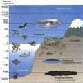 How does the biosphere differ from other layers of the earth?