The southernmost city of the USSR. Extreme points of Russia
Russia is located in the north of the Eurasian continent, occupying about a third of its territory (31.5%). The extreme northern and eastern points of the continent are also the extreme points of Russia. The country is located in two parts of the world and occupies the eastern sector of Europe and the northern part of Asia. Russia is washed by the seas of three oceans: the Atlantic, Arctic and Pacific.
The border between Europe and Asia within Russia is drawn along the Ural Mountains and the Kuma-Manych depression. Only a little more than 1/5 of the country's area belongs to Europe (about 22%). Moreover, the European territory of Russia often means the entire territory lying west of the Urals (about 23% of the area). In any case, the Asian part of Russia accounts for over 3/4 of the country's territory. The 180th meridian passes through Wrangel Island and Chukotka, therefore, the eastern outskirts of Russia lies in the Western Hemisphere. The geographical center of Russia is located in the Krasnoyarsk Territory, Evenki Autonomous Okrug on Lake Vivi. The center of Asia is located in Tuva, near Kyzyl.
The Russian Federation is the largest state in the world in terms of territory; the country's area is 17 million 75 thousand 400 km 2 (one eighth of the world's territory). The area of Russia is 1.7 times more area Europe and 1.8 times the area of the United States, 2 times the area of the People's Republic of China and 29 times the area of the largest European state - Ukraine.
Northernmost point
The northernmost point of Russia on the mainland is located far beyond the Arctic Circle at Cape Chelyuskin (77° 43" N).
Cape Chelyuskin, which is the northernmost point of the Taimyr Peninsula and the Eurasian mainland, was first reached by man in 1742. Then the expedition led by Semyon Ivanovich Chelyuskin named the cape East-Northern. It took place as part of the Great Northern Expedition, which was approved by the Admiralty Board, which believed that it was necessary to explore in detail the north of Russia from Pechora to Chukotka and make a description of those places. In honor of Semyon Chelyuskin, a polar navigator and explorer of the north of Russia, the cape was named already in 1842, when the centenary of his expedition was celebrated.

Chelyuskin’s travel journal, in which he shares his impressions of his dog sledding journey, the hard way, done by him with his comrades, and their arrival at the cape, is still kept in St. Petersburg, in the archive navy.
The northernmost point of the Taimyr Peninsula has a harsh climate. Winter here lasts all year round, the snow practically never melts, and the temperature in July and August usually does not exceed +1C°.
The second person to visit this cape was a geologist and geographer from Sweden, Nils Nordenskiöld. The third was the Norwegian Fridtjof Nansen, who on September 9, 1893 sailed past Cape Chelyuskin in a heavy snowstorm on the ship Fram.

Currently, the station is called a radio meteorological center, where from 8 to 10 people spend the winter. A number of residential buildings and scientific pavilions were built. Some buildings are abandoned and not in use. The northernmost airfield of continental Eurasia, “Cape Chelyuskin,” is also located here, which is serviced by the Khatanga United Aviation Enterprise. All that remains of the airfield is a helipad, maintained by the military.
In 1932, a polar station was established on the cape, to which an observatory was later added. Now the station has been transferred to meteorological status. About 10 people constantly spend the winter there. Communication with the mainland and civilization is provided by the Cape Chelyuskin airfield with a helipad.

And one more island point: Cape Fligeli on Rudolf Island in the Franz Josef Land archipelago is located even further north - 81° 49" N, the distance from Cape Fligeli to the North Pole is only 900 km.
Rudolf Island is the northernmost of the Franz Josef Land islands. Cape Fligeli on the island is the northernmost point of land, belonging to Russian Federation, at the same time the northernmost point of Europe. The island administratively belongs to the Arkhangelsk region. Area 297 km2. Almost completely covered by a glacier.

The island, like the entire Franz Josef Archipelago, was discovered in 1873 by the Austro-Hungarian expedition of explorer J. Payer, and was named after Rudolf, Crown Prince of Austria. In 1936, the base of the first Soviet air expedition to North Pole. From there, in May 1937, four heavy four-engine ANT-6 aircraft brought the Papaninites to the top of the world.
The meteorological station on Rudolf Island was opened in August 1932 as part of the Second International Polar Year program. For the first wintering, 4 people remained, led by N.F. Balabin. A year later, the station was mothballed, and work continued again in the summer of 1936. Initially, the station was equipped as a base for the 1937 air expedition to the North Pole. Airfields were equipped near the station and on the ice dome of the island. In the period from April 1942 to 1947, it was again mothballed. The last period of work was 1947-1995.
Southernmost point
According to the first version, the extreme southern point is located southwest of Mount Bazardyuzyu in the eastern part of the Main, or Watershed, ridge of the Greater Caucasus, on the border of Dagestan and Azerbaijan. The latitude of the point is 41° 11" N. The distance between the extreme northern and southern points exceeds 40° along the meridian, and the northern continental point is 36.5° away from the southern one. This is just over 4 thousand km.

All reference books indicate that Bazardyuzyu (4,466 m) is the highest of the mountain peaks of the Republic of Dagestan and neighboring Azerbaijan. 41°13′16″ n. w. 47°51′29″ E. d.

However, there is another version: The extreme southern bend of the border between the Russian Federation and Azerbaijan is located several kilometers southwest of the Bazardyuzyu peak. Closer to the southern point of Russia is Mount Ragdan (41°12" N). And the village of Kurush is the southernmost populated area...

The peak on the left is Bazarduzu, on the right is Ragdan
The Usukhchaya Valley is unique in terms of possessing the epithets “most”, “most”, “most”. Here is the easternmost glacier of Dagestan - Tikhitsar. And the southernmost glacier of Dagestan and Russia, Charyn, also lies in the river basin. Next to the Charyn glacier rises Mount Ragdan, the southernmost point of the Russian Federation. One of the longest and highest rock walls of the Caucasus is the Western Wall of Erydag - the pride of our wall climbers. Finally, the highest peak of Dagestan - Bazarduzi (4466 m) is also adjacent to the Usukhchaya valley. One more thing can be noted natural phenomenon valleys. From the ridge of Erydag, the Charaur waterfall, the highest in Dagestan, falls to a depth of 300 meters.

Closer to the southern point of Russia is Mount Ragdan (41°12" N), but it can only be found on large-scale maps
This extent of the territory from north to south, combined with the latitudinal position, determines the uneven supply of heat to the surface of the country and the formation within its borders of three climatic zones (Arctic, subarctic and temperate) and ten natural areas(from arctic deserts to temperate deserts). The main part of Russia's territory is located between 70 and 50° N. latitude. About 20% of the territory lies beyond the Arctic Circle. The area of the Northern regions is 10 million km 2, in this respect only Canada can serve as an analogue.
Westernmost point
The extreme western point of Russia is located in the Kaliningrad region on the sandy Baltic spit of the Gulf of Gdansk Baltic Sea at 19° 38" 30" E. But due to the fact that the Kaliningrad region is separated from the rest of Russia by the territory of other states and is an enclave, the extreme western point has turned into a kind of “island” point.

They also call the western point of the compact part of Russia, that is, without taking into account the Kaliningrad region, - in the Pskov region, just north of the junction of the borders of Estonia, Latvia and Russia (27 ° 17 "E).
Easternmost point
The easternmost point of Russia on the mainland is located at Cape Dezhnev (169° 40" W) - Ratmanov Island in the Bering Strait is located even further east - 169° 02" W.

Cape Dezhnev, one of the most brutal places on the Chukotka Peninsula. Here the rocks are piled one on top of the other, there is often fog and a piercing wind constantly blows. From this point to the extreme western point of America - Cape Prince of Wales - 86 kilometers.
Despite the remoteness from civilization, these places have attractions. The lighthouse named after Semyon Dezhnev and an ancient cross installed nearby, the abandoned whaling village of the 18th-20th centuries - Naukan (it was disbanded under Soviet rule). However, those who climb to these regions come to see the unique fauna: there are countless bird colonies here, there is a walrus and seal rookery, and in the spring you can see polar bears with cubs. Sometimes killer whales and gray whales swim very close to the shore.

Semyon Ivanovich Dezhnev in 1648 circumnavigated the Chukotka Peninsula from the north and proved that it was possible to get from Europe to China through the northern seas. He passed through the strait separating America from Eurasia 80 years earlier than Vitus Bering, but little was known about Russian pioneers in the Old World. Therefore, the glory went to Bering. However, in 1879, restoring justice, the Swedish Arctic explorer Nils Nordenskiöld named the extreme eastern point of Eurasia - Cape Dezhnev, after the Russian navigator. Until that time the cape was called Eastern.
How to get there: the nearest village of Uelen is located 10 kilometers from Cape Dezhnev, and the nearest airport is in Provideniya Bay, where planes fly from Anadyr.

Ratmanov Island has irregular shape(approximately 9 km long, 5 km wide) and an area of about 10 square meters. km; It's practically a large rock with a flat top. Just 4 km 160 m away is Kruzenshtern Island (formerly Little Diomede), with an area of about 5 square meters. km, which belongs to the USA. There is also Fairway Rock. The name Diomede was given to this archipelago by Vitus Bering, who approached the large island on the boat “Saint Gabriel” on August 16, 1728, the day of Saint Diomede. But even before this name, Ratmanov Island already had a name - Imaklik (translated from Eskimo - “surrounded by water”), which was given to it by the Eskimos who lived on it for more than two thousand years. By the way, the Eskimos called Krusenstern Island (formerly Little Diomede) Ingalik, which means “opposite”.
The story of the island being named after Ratmanov is as follows. In 1816, the famous navigator Otto Kotzebue, while exploring the Bering Strait, mistakenly counted not three islands in the Diomede archipelago (as had been shown on the map since 1732), but four islands. He decided to give the “newly discovered” island the name of his colleague, naval officer Makar Ratmanov, with whom he took part in a round-the-world expedition several years earlier. When the error was discovered, they decided to leave Ratmanov’s name on the map, and from the middle of the 19th century, Big Diomede changed its name.

Western (large) - Ratmanov Island
The island is like a gable roof, with an extensive, gentler northern slope. From south to north, as if bending it in the middle, a river with marshy banks flows, and closer to the raised edges scatterings of bare stones and bizarre outcrops begin. The southern slope is smaller, but steeper. The remains on it are more numerous and the steep banks are higher. The junction of both slopes forms a small ridge, the highest point of which is called Roof Mountain. The island occupies a key position on the border of Asia and North America and two oceans - the Pacific and the Arctic. It overlooks a huge water area. For tens of kilometers to the west, north and east, it is easy to trace the movements of marine animals and the flights of birds.
The islands were inhabited by brave Inupik Eskimo sailors. Barter trade between Asian and American Eskimos took place through them; they were at the center of all events in the Northern Bering Sea and, creating their own culture, adopted a lot from the cultural traditions that already existed on both continents. In 1948, with the outbreak of the Cold War between the USSR and the USA, the inhabitants of the island were resettled to the mainland.

Now there is a Russian border outpost on Ratmanov Island. On Krusenstern Island there is a village with a population of 600 people. The Russian-American border, as well as the international date line, runs between these islands. Getting to Ratmanov Island is not just difficult, but extremely difficult. And not only because it is factual state border, but also due to weather conditions - 300 days a year the island is shrouded in thick fog. Most shortcut: from Anadyr by helicopter via St. Lawrence. But this is only after receiving permission from the SVRPU. But it's worth it!
The distance between the western and eastern outskirts of Russia is 171° 20" or almost 10 thousand km. With the enormous extent of the territory from west to east, the degree of continentality of the climate changes, which entails the manifestation of sectoral changes in nature. There are 10 time zones within the Russian Federation The highest point in Russia is Mount Elbrus (5642 m), located in the Karachay-Cherkess Republic on the border with the Kabardino-Balkarian Republic. The lowest absolute height is noted in the Caspian depression (-28 m).
Our state covers such a vast territory that it contains eleven time zones and three climate zones, as well as ten natural zones. This makes the Russian Federation a unique country of its kind. In this article we will talk about the Far Eastern points of Russia.
The easternmost point of Russia, an oblong island with an area of five by nine kilometers, did not always have this name. The discoverer Vitus Bering first named it Big Diomede, and the nearby island - Little Diomede. But the Eskimos, who lived here for hundreds of years, simply called the island “Imaklik,” which translated means “surrounded by water.” The current name appeared due to an error: in 1816, the traveler Otto Kotzebue marked the island on the map in honor of his friend Makar Ratmanov - although the island had already been discovered by Bering. Nevertheless, the name was left. Rotmanov Island is covered with thick fog most of the year.
With its shape, Ratmanov Island resembles a gable roof. The slope on the north side is more spacious and gentle. The river flows in the direction from south to north. The southern slope is quite steep and steep in places. At the “junction” of the slopes, a mountain range was formed, from the top of which you can see the expanses of the sea, as well as track the movements of animals and birds.
Photography is prohibited on the island
The first people to explore the island were the Eskimos from the Inupik tribe, who established trade with the Eskimos from America and Asia. They had their own rich culture, partly combining the traditions of both the East and the West. During the Cold War, in 1948, all settlers were forcibly removed from the island.
Today, there is a Russian border outpost on Ratmanov Island. The village, located on a neighboring island, is home to 600 people, and the Russian-American border and the international date line run between the islands. The island is an object of national importance. To get to Ratmanov Island, you need permission from the border department.
The easternmost point of the continental territory is Cape Dezhnev
The cape was discovered in 1648 by traveler S. Dezhnev, and, as it turned out, it is located on the edge of Russian land. This is a small mountain range, reaching a height of approximately 740 meters. It is tightly embraced on three sides by the cold waves of the Arctic Ocean. There are so few people in these places that nature is practically untouched. The development of tourism here is hampered mainly by the harsh climate.
Nevertheless, even here you can find populated areas – the villages of Naukan and Uelen. People usually come to the first only temporarily, for fishing, but the second is rightfully called the capital of this region. Seven hundred people live in it, mostly the indigenous population - Eskimos and Chukchi. They are engaged in the traditional work of their distant ancestors: raising deer, fishing, hunting whales. There are quite a lot of bone carvers here; they even have their own museum for their products.

There is, one might say, no summer at Cape Dezhnev, spring and autumn are barely noticeable and merge with each other, and winter lasts eight months in a row
There is also one abandoned since the time Soviet Union aerodrome. Yes, I must admit, the whole area looks rather abandoned, as if the country doesn’t need it. The population is accustomed to this and considers it the norm of life.
The easternmost city is Anadyr
On Far East Chukotka is located - sparsely populated Russian region. Its population does not exceed 50 thousand, and the population of the capital, Anadyr, is only 15 thousand people. To truly appreciate this unusual city, built at one time to protect against strangers, you need to thoroughly walk around it for several days, preferably before looking into the remote tundra for comparison.
This eastern city was founded in 1889 by order of the Tsar. True, its original name sounded like Novo-Mariinsk. Construction proceeded rather slowly, with emphasis placed on retail and government warehouses. Fifteen years later, a radio station appeared in the city, at that time it became one of the most powerful in Russia. After revolutionary events Soviet power was established here much later than in other regions - in 1924. And it was then that the current name was approved - Anadyr.

Anadyr is a Chukchi word supposedly derived from the name of the river
Three years later, the village became the center of the Anadyr region, and then the entire Chukotka region. In the 1950s, an estuary was built here, which served as a powerful impetus for development settlement. Thus, in 1965 the village received city status. If we talk about modern events in the life of Anadyr, then in 2004 it received the status of an urban district, including another settlement. The city is not divided into districts.
The climate in the city is quite cold, and people who are unaccustomed to it may not feel comfortable. And yet, thanks to the proximity of the sea, it is much warmer here than in the rest of Chukotka. Around the city there is almost constant permafrost, which means that the earth does not warm up above zero degrees.
In terms of the economy, the main sources of financial and other resources are enterprises such as a fish processing plant, a thermal power plant, a gas engine station, and a wind power plant. Mineral resources such as coal and gold are also actively mined.
The majority of the population is engaged in fishing or hunting; there are deer breeding farms. Culture is represented by a library and a museum, and science by a university, school, and laboratory. In 2013, after seven years of construction, the lift system was opened, which is located in the ski area.

Anadyr can be called a bright city of Russia, for this it was necessary to paint the gray Soviet buildings, and the appearance changed radically
In 2011, in the vicinity of Anadyr, a large area of perfectly preserved petrified forest from the Upper Paleocene was discovered, although scientists had previously claimed that there was no forest in this area. Later, several more fossil objects were discovered, mostly associated with flora. The collected specimens were placed in the National Chukotka Museum.
The city has significant monuments - for example, a bronze worship cross, a memorial in memory of Chukotka’s participation in the Great Patriotic War or a ten-meter statue dedicated to St. Nicholas the Wonderworker.
The transport structure of the city is represented by public transport, a port, and an airfield. From the port, ships sail to Vladivostok, Magadan and other continental ports. True, the navigation period is very short; the rest of the time the waters freeze. As for the airport, it is an important transport hub. In addition to regular passenger flights, all year round Cargo transportation is carried out by helicopters.

The flight from Moscow to Anadyr will take 8 hours, and the ticket will cost approximately 30 thousand rubles
Despite the considerable distance from civilization, the eastern part of the Russian Federation is rich in attractions, and not to mention the wonderful nature. If possible, you should definitely visit the listed places to feel their atmosphere.
Russia ranks first in the world in terms of territory, having borders with 18 countries, including two partially recognized ones. This is a well-known fact. And this is what the extreme points look like Russian state, spread over two continents, not everyone knows. P We present to your attention a selection of photographs demonstrating the most extreme points of Russia.
The northernmost point of Russia
We will consider the extreme points with the inclusion of islands and exclaves, therefore the extreme northern point of our country will be Cape Fligeli, which is located on Franz Josef Land in the Arkhangelsk region.
 Cape Fligeli is the extreme northern point of land in Russia, Europe and all of Eurasia.

It got its name from the Austrian cartographer August von Fliegeli who discovered it.

Of course, apart from birds and polar bears, there is not a soul here...

Just look at this power.

In the distance you can see a huge icy part of the cape.


Looking at tiny people against the backdrop of a huge block of ice, you understand the power of the elements.

Polar bears.

Cold regal beauty and external calm...
Cape Chelyuskin

And this cape is the northernmost continental point of Russia and Eurasia. The water depth at the cape is 10 meters.

The climate here is Arctic and very harsh. Climatic winter reigns here for 11.5 months.

Currently, there is a station on the cape where 8 to 10 people spend the winter.
The easternmost point of Russia

Ratmanov Island or Big Diomede, belonging to the Chukotka Autonomous Okrug, is the easternmost point of Russia.

It received its name in honor of M.I. Ratmanov, a Russian navigator.

Here on the island there is a base for Russian border guards, but there is no population. The depth of the waters off the coast reaches 43 meters.

3.76 km from Big Diomede, as Ratmanov Island is also called, is Little Diomede, owned by the United States. This photo was taken just from its banks.
Cape Dezhnev

This cape is the extreme eastern continental point of the Chukotka Peninsula and, accordingly, the extreme eastern continental point of Russia and all of Eurasia. Named after Semyon Dezhnev, a Russian navigator.

Just in memory of Semyon Dezhnev, a lighthouse in the form of a tetrahedral obelisk was installed at an altitude of about 100 meters above sea level.

Currently, individual Eskimo families live on the cape.
The westernmost point of Russia

This is the Normeln border post, located on the Baltic Spit in the Kaliningrad region.
The Union of Soviet Socialist Republics is located on the territory of two parts of the world - in the eastern half of Europe and in northern Asia.
It stretches for 4.5 thousand km from north to south and more than 9 thousand km from west to east. The extreme northern point of the USSR on the mainland - Cape Chelyuskin - lies at 77°43′ N, latitude; the northernmost island is on Rudolf Island (Franz Josef Land) at 81°51′ N. w. The southernmost point is at Central Asia, south of the village Kushki, at 35°08′ N. w. In the Kaliningrad region on the Baltic Spit at 19°33′ E. (and on the shore of the Vistula Lagoon at 19°38′ E) lies the extreme western point of the country; the extreme eastern mainland - on Cape Dezhnev in Chukotka, at 169°40′w. d.; the easternmost island is in the Bering Strait on one of the Diomede Islands.
The USSR is the largest country in the world by area. Together with the islands, its territory is 22.4 million km 2. This exceeds the area of the largest state Western Europe- France 40 times. Within the USSR you can place the territory of the United States three times (without Alaska), twice the whole of Europe.
The natural conditions of the USSR are exceptionally diverse: in the north of the country there are arctic deserts and tundras, in which the air temperature of the warmest month is close to 0°, and in the south there are subtropical areas where winter is so warm that at its height you can find flowering plants; coniferous taiga and sphagnum swamps in the north and black soil steppes, semi-deserts and deserts in the south; the air of Colchis is saturated with moisture, the annual precipitation here exceeds 2500 mm, and at the same latitude in Central Asia lie the Kara-Kum and Kyzylkum deserts, where 150-100 or less millimeters of precipitation falls per year; monotonous plains and lowlands - Russian, West Siberian and Turanian - alternate with high mountain ranges and plateaus; Stalin Peak in the Pamirs - the highest peak of the USSR - rises 7495 m above sea level, and the vast Caspian lowland lies below its level; On the Mangyshlak Peninsula there is a dry depression called Karagi (Batyr), which has an absolute elevation of 132 m below sea level.
The natural conditions of the USSR are favorable for the development of a wide variety of branches of agriculture and animal husbandry.
The country's depths contain large reserves of minerals. The Soviet Union is provided with all types of mineral raw materials necessary for industrial development. The USSR ranks first in the world in terms of reserves of such important minerals as coal, iron, copper, manganese, lead, zinc, tungsten, and one of the first in the world in terms of oil reserves.
Everywhere - in the tundra and subtropics, in the steppes and high mountain pastures - they work selflessly soviet people. There are no longer any areas left in the USSR where “the human foot,” even in the ice of the Central Arctic, drifting research stations are now constantly operating.
The large size of the territory of the Soviet Union determines the large length of its borders - about 60 thousand km; At the same time, the sea borders account for 43 thousand km. The nature of the borders in the north, west, south and east of the country is not the same.
The northern border of the USSR is maritime. It crosses the Arctic Ocean to the Pole approximately along the meridians of the extreme western and eastern points of the country's Arctic coast. Except in the extreme east, this coast is low-lying. In the central part it extends to the north, passing 77° N in Taimyr. sh., and in the west and east it drops to the south beyond 70° N. w. On the recently uninhabited and little-explored coast of the Arctic Ocean in Soviet years large port and industrial cities grew. The seas located at the northern borders connect the western regions of the country with the Far East by sea. From the coast of the Arctic Ocean and the Arctic islands lies the shortest air and sea route to the countries of North America - Canada and the USA.
The western border of the USSR runs on land and along its entire length - from the Barents Sea to the Black Sea - does not have clearly defined natural boundaries. In the north-west of the Kola Peninsula it goes through treeless tundra and forest-tundra open forest, then enters the taiga of the Kola Peninsula and Karelia. Swamps, coniferous forests, lakes and rocky hills accompany the state border here all the way to the Baltic Sea coast. To the south it crosses the mixed forests of Belarus and the forest-steppe of Ukraine. Further to the south, the plain along which the border followed is interrupted by the mid-mountain landscapes of the Ukrainian (Wooded) Carpathians. The southwestern section of the border runs along the Prut River and the lower Danube in the dry Black Sea steppes.
The western neighbors of the USSR are Norway, Finland, the Polish People's Republic, the Czechoslovak People's Republic, the Hungarian People's Republic, and the Romanian People's Republic.
The southern border of the USSR, like the western border, is predominantly land. It begins on the shores of the Black Sea and ends on the coast of the Sea of Japan, crossing a wide variety of landscapes: the damp subtropical forests of Transcaucasia, the arid deserts of Central Asia, the eternal snows and glaciers of the highlands, the Siberian taiga, the Transbaikal steppes, and the Ussuri mixed forests. For a considerable distance, the southern border passes through inaccessible and sparsely populated mountainous regions: between the Black and Caspian Seas - along the mountains of Transcaucasia; in the south of Central Asia - along the Kopet-Dag ridge, the Pamir Plateau and the Tien Shan mountains; in Siberia it crosses the Altai, Eastern Sayan and Transbaikalia ranges. In Eastern Transbaikalia and the Far East, the state border follows mainly the Argun, Amur and Ussuri rivers. Our southern neighbors are: Türkiye, Iran, Afghanistan, People's Republic of China, Mongolian People's Republic, Democratic People's Republic of Korea. In the Pamir region, the territory of Afghanistan separates the USSR from India and Pakistan by a narrow fifteen-kilometer corridor. The eastern border of the USSR, like the northern one, is sea. She passes through Pacific Ocean and its seas. The closest neighbors of the USSR are eastern borders- Japan (in the south) and the USA (in the north). The USSR recognizes its modern state borders as fair. Being a peace-loving state, the Union of Soviet Socialist Republics does not interfere in the internal affairs of neighboring countries, and we oppose the seizure of foreign lands and the construction of military bases on them.
Russia is located in the north of the Eurasian continent, occupying about a third of its territory (31.5%). The extreme northern and eastern points of the continent are also the extreme points of Russia. The country is located in two parts of the world and occupies the eastern sector of Europe and the northern part of Asia. Russia is washed by the seas of three oceans: the Atlantic, Arctic and Pacific.
The border between Europe and Asia within Russia is drawn along the Ural Mountains and the Kuma-Manych depression. Only a little more than 1/5 of the country's area belongs to Europe (about 22%). Moreover, the European territory of Russia often means the entire territory lying west of the Urals (about 23% of the area). In any case, the Asian part of Russia accounts for over 3/4 of the country's territory. The 180th meridian passes through Wrangel Island and Chukotka, therefore, the eastern outskirts of Russia lies in the Western Hemisphere. The geographical center of Russia is located in the Krasnoyarsk Territory, Evenki Autonomous Okrug on Lake Vivi. The center of Asia is located in Tuva, near Kyzyl.
The Russian Federation is the largest state in the world in terms of territory; the country's area is 17 million 75 thousand 400 km2 (one eighth of the world's territory). The area of Russia is 1.7 times larger than the area of Europe and 1.8 times larger than the area of the United States, 2 times larger than the area of the People's Republic of China and 29 times larger than the area of the largest European state - Ukraine.
Northernmost point
The northernmost point of Russia on the mainland is located far beyond the Arctic Circle at Cape Chelyuskin (77° 43" N).
Cape Chelyuskin, which is the northernmost point of the Taimyr Peninsula and the Eurasian mainland, was first reached by man in 1742. Then the expedition led by Semyon Ivanovich Chelyuskin named the cape East-Northern. It took place as part of the Great Northern Expedition, which was approved by the Admiralty Board, which believed that it was necessary to explore in detail the north of Russia from Pechora to Chukotka and make a description of those places. In honor of Semyon Chelyuskin, a polar navigator and explorer of the north of Russia, the cape was named already in 1842, when the centenary of his expedition was celebrated.

Chelyuskin's travel journal, in which he shares his impressions of his dog sled journey, the difficult journey he made with his comrades, and their arrival at the Cape, is still kept in St. Petersburg, in the archives of the navy.
The northernmost point of the Taimyr Peninsula has a harsh climate. Winter here lasts all year round, the snow practically never melts, and the temperature in July and August usually does not exceed +1C°.
The second person to visit this cape was geologists and geographer from Sweden Nils Nordenskiöld. The third was the Norwegian Fridtjof Nansen, who on September 9, 1893 sailed past Cape Chelyuskin in a heavy snowstorm on the ship Fram.

Currently, the station is called a radio meteorological center, where from 8 to 10 people spend the winter. A number of residential buildings and scientific pavilions were built. Some buildings are abandoned and not in use. The northernmost airfield of continental Eurasia, “Cape Chelyuskin,” is also located here, which is serviced by the Khatanga United Aviation Enterprise. All that remains of the airfield is a helipad, maintained by the military.
In 1932, a polar station was established on the cape, to which an observatory was later added. Now the station has been transferred to meteorological status. About 10 people constantly spend the winter there. Communication with the mainland and civilization is provided by the Cape Chelyuskin airfield with a helipad.

And one more island point: Cape Fligeli on Rudolf Island in the Franz Josef Land archipelago is located even further north - 81° 49" N, the distance from Cape Fligeli to the North Pole is only 900 km.
Rudolf Island is the northernmost of the Franz Josef Land islands. Cape Fligeli on the island is the northernmost point of land belonging to the Russian Federation, at the same time the northernmost point of Europe. The island administratively belongs to the Arkhangelsk region. Area 297 km?. Almost completely covered by a glacier.

The island, like the entire Franz Josef Archipelago, was discovered in 1873 by the Austro-Hungarian expedition of explorer J. Payer, and was named after Rudolf, Crown Prince of Austria. In 1936, the base of the first Soviet air expedition to the North Pole was established on the island. From there, in May 1937, four heavy four-engine ANT-6 aircraft brought the Papaninites to the top of the world.
The meteorological station on Rudolf Island was opened in August 1932 as part of the Second International Polar Year program. For the first wintering, 4 people remained, led by N.F. Balabin. A year later, the station was mothballed, and work continued again in the summer of 1936. Initially, the station was equipped as a base for the 1937 air expedition to the North Pole. Airfields were equipped near the station and on the ice dome of the island. In the period from April 1942 to 1947, it was again mothballed. The last period of work was 1947-1995.
Southernmost point
According to the first version, the extreme southern point is located southwest of Mount Bazardyuzyu in the eastern part of the Main, or Watershed, ridge of the Greater Caucasus, on the border of Dagestan and Azerbaijan. The latitude of the point is 41° 11" N. The distance between the extreme northern and southern points exceeds 40° along the meridian, and the northern continental point is 36.5° away from the southern one. This is just over 4 thousand km.

All reference books indicate Bazardyuzyu (4,466 m*) - the highest of the mountain peaks of the Republic of Dagestan and neighboring Azerbaijan. 41°13′16″ n. w. 47°51′29″ E. d.

However, there is another version: The extreme southern bend of the border between the Russian Federation and Azerbaijan is located several kilometers southwest of the Bazardyuzyu peak. Closer to the southern point of Russia is Mount Ragdan (41°12" N). And the village of Kurush is the southernmost populated area....

The peak on the left is Bazarduzu, on the right is Ragdan
The Usukhchaya Valley is unique in terms of possessing the epithets “most”, “most”, “most”. Here is the easternmost glacier of Dagestan - Tikhitsar. And the southernmost glacier of Dagestan and Russia, Charyn, also lies in the river basin. Next to the Charyn glacier rises Mount Ragdan - the southernmost point of the Russian Federation. One of the longest and highest rock walls of the Caucasus is the Western Wall of Erydag - the pride of our wall climbers. Finally, the highest peak of Dagestan - Bazarduzi (4466 m) is also adjacent to the Usukhchaya valley. One more natural phenomenon of the valley can be noted. From the ridge of Erydag, the Charaur waterfall, the highest in Dagestan, falls to a depth of 300 meters.

Closer to the southern point of Russia is Mount Ragdan (41°12" N), but it can only be found on large-scale maps.
This extent of the territory from north to south, combined with the latitudinal position, determines the uneven supply of heat to the surface of the country and the formation within its borders of three climatic zones (Arctic, subarctic and temperate) and ten natural zones (from arctic deserts to temperate deserts). The main part of Russia's territory is located between 70 and 50° N. latitude. About 20% of the territory lies beyond the Arctic Circle. The area of the Northern regions is 10 million km2; in this respect, only Canada can serve as an analogue.
Westernmost point
The extreme western point of Russia is located in the Kaliningrad region on the sandy Baltic spit of the Gdansk Bay of the Baltic Sea at 19° 38" 30" east. But due to the fact that the Kaliningrad region is separated from the rest of Russia by the territory of other states and is an enclave, the extreme western point has turned into a kind of “island” point.

They also call the western point of the compact part of Russia, that is, excluding the Kaliningrad region, - in the Pskov region, just north of the junction of the borders of Estonia, Latvia and Russia (27 ° 17 "E).
Easternmost point
The easternmost point of Russia on the mainland is located at Cape Dezhnev (169° 40" W) - Ratmanov Island in the Bering Strait is located even further east - 169° 02" W.

Cape Dezhnev, one of the most brutal places on the Chukotka Peninsula. Here the rocks are piled one on top of the other, there is often fog and a piercing wind constantly blows. From this point to the extreme western point of America - Cape Prince of Wales - 86 kilometers.
Despite the remoteness from civilization, these places have attractions. The lighthouse named after Semyon Dezhnev and an ancient cross installed nearby, the abandoned whalers' village of the 18th-20th centuries - Naukan (it was disbanded under Soviet rule). However, those who climb to these regions come to see the unique fauna: there are countless bird colonies here, there is a walrus and seal rookery, and in the spring you can see polar bears with cubs. Sometimes killer whales and gray whales swim very close to the shore.

Semyon Ivanovich Dezhnev in 1648 circumnavigated the Chukotka Peninsula from the north and proved that it was possible to get from Europe to China through the northern seas. He passed through the strait separating America from Eurasia 80 years earlier than Vitus Bering, but little was known about Russian pioneers in the Old World. Therefore, the glory went to Bering. However, in 1879, restoring justice, the Swedish Arctic explorer Nils Nordenskiöld named the extreme eastern point of Eurasia, Cape Dezhnev, after the Russian navigator. Until this time, the cape was called Vostochny.
How to get there: the nearest village of Uelen is located 10 kilometers from Cape Dezhnev, and the nearest airport is in Provideniya Bay, where planes fly from Anadyr.

Ratmanova Island has an irregular shape (about 9 km long, 5 km wide) and an area of about 10 square meters. km; It's practically a large rock with a flat top. Just 4 km 160 m away is Kruzenshtern Island (formerly Little Diomede), with an area of about 5 square meters. km, which belongs to the USA. There is also Fairway Rock. The name Diomede was given to this archipelago by Vitus Bering, who approached the large island on the boat “Saint Gabriel” on August 16, 1728, the day of Saint Diomede. But even before this name, Ratmanov Island already had a name - Imaklik (translated from Eskimo - “surrounded by water”), which was given to it by the Eskimos who lived on it for more than two thousand years. By the way, the Eskimos called Krusenstern Island (formerly Little Diomede) Ingalik, which means “opposite”.
The story of the island being named after Ratmanov is as follows. In 1816, the famous navigator Otto Kotzebue, while exploring the Bering Strait, mistakenly counted not three islands in the Diomede archipelago (as had been shown on the map since 1732), but four islands. He decided to give the “newly discovered” island the name of his colleague, naval officer Makar Ratmanov, with whom he took part in a round-the-world expedition several years earlier. When the error was discovered, they decided to leave Ratmanov’s name on the map, and from the middle of the 19th century, Big Diomede changed its name.

Western (large) - Ratmanov Island
The island is like a gable roof, with an extensive, gentler northern slope. From south to north, as if bending it in the middle, a river with marshy banks flows, and closer to the raised edges scatterings of bare stones and bizarre outcrops begin. The southern slope is smaller, but steeper. The remains on it are more numerous and the steep banks are higher. The junction of both slopes forms a small ridge, the highest point of which is called Mount Roof. The island occupies a key position on the border of Asia and North America and two oceans - the Pacific and the Arctic. It overlooks a huge water area. For tens of kilometers to the west, north and east, it is easy to trace the movements of marine animals and the flights of birds.
The islands were inhabited by brave Inupik Eskimo sailors. Barter trade between Asian and American Eskimos took place through them; they were at the center of all events in the Northern Bering Sea and, creating their own culture, adopted a lot from the cultural traditions that already existed on both continents. In 1948, with the outbreak of the Cold War between the USSR and the USA, the inhabitants of the island were resettled to the mainland.

Now there is a Russian border outpost on Ratmanov Island. On Krusenstern Island there is a village with a population of 600 people. The Russian-American border, as well as the international date line, runs between these islands. Getting to Ratmanov Island is not just difficult, but extremely difficult. And not only because this is actually a state border, but also due to weather conditions - 300 days a year the island is shrouded in thick fog. The shortest route: from Anadyr by helicopter via St. Lawrence. But this is only after receiving permission from the SVRPU. But it's worth it!
The distance between the western and eastern outskirts of Russia is 171° 20" or almost 10 thousand km. With the enormous extent of the territory from west to east, the degree of continentality of the climate changes, which entails the manifestation of sectoral changes in nature. There are 10 time zones within the Russian Federation The highest point in Russia is Mount Elbrus (5642 m), located in the Karachay-Cherkess Republic on the border with the Kabardino-Balkarian Republic. The lowest absolute height is noted in the Caspian depression (- 28 m).
 Food chains, food webs and trophic levels Create your own example of a food web
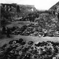 Concentration camps in the USSR 1941 1945
 Instantaneous movement speed