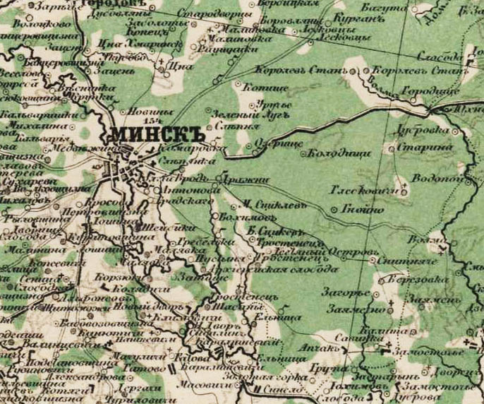
Map of Vitebsk and Minsk provinces 1920. Old maps of Belarus
It was necessary to accurately establish the boundaries of land holdings of both individuals and peasant communities, cities, churches and other possible land owners.
Sample of Babinovichi district
Vitebsk province
Vitebsk district 2 versts
1.2 versts
2 versts
1 mile
2 versts
2 versts
Nevelsky district 2 versts
Polotsk district 2 versts
2 versts
Sebezh district 2 versts
2 versts
Minsk province
2 versts
2 versts
2 versts
2 versts
2 versts
2 versts
2 versts
2 versts
2 versts
2 versts
Mogilev province
Belitsky district 2 versts
2 versts
Klimovichi district 2 versts
Kopys district 2 versts
Mogilev district 2 versts
Mstislavsky district 2 versts
Orsha district 2 versts
Rogachevsky district 2 versts
Sennen district 2 versts
Starobykhovsky district 2 versts
Chaussky district 2 versts
Cherikovsky district 2 versts
3-mile maps of Belarus.
F.F. the scale is three versts, which translated into the modern system of calculations will be 1:126000, that is, 1 cm – 1,260 km. These old ones cards Dating back to the second half of the 19th century, maps were printed starting in 1860. and until the beginning of 1900.
All maps with good detail of objects, showing churches, mills, cemeteries, relief, type of terrain and other objects.

Sample 3 layout
Maps can be downloaded.
Special Map of European Russia.
is a huge cartographic publication, running on 152 pages and covering a little more than half of Europe. Mapping lasted 6 years, from 1865 to 1871. Map scale: 1 inch - 10 versts, 1:420000, which in the metric system is approximately 1 cm - 4.2 km.
Maps can be downloaded.
Maps of the Red Army.
(Workers' and Peasants' Red Army) were compiled and published both in the USSR in the period from 1925 to 1941, and in Germany, in preparation for the war, in the period 1935-41. On maps printed in Germany, the name in German is often printed next to the Russian name of a village, river, etc.
250 meters.


Poland 1:25 000
500 meters.

kilometres.

Maps can be downloaded.
Polish WIG cards.
Maps were published in pre-war Poland - Military Institute of Geography (Wojskowy Instytut Geograficzny), the scale of these maps is 1:100000 and 1:25000 or, to put it simply, 1 cm - 1 km and 1 cm -250 m, the quality of the maps is very good - 600 dpi, respectively, and the size of the maps is also not small, in fact, everything is more than 10 megabyte.
Intelligent, detailed and search engine-friendly maps. All the smallest details are visible: farmsteads, dungeons, farmsteads, manors, taverns, chapels, mills, etc.
Kilometer.

sample WIG card.
250 meter

One-verst map of Belarus.
A one-verst map of the western border area on a scale of 1-verst per inch (1:42000) was published from the 1880s until the First World War, and was republished until the end of the 1930s.
Maps at a scale of 1:42000.

Military topographical 2-mile map of the Western Border Space.
Maps at a scale of 1:84000 (two-layer). Two-mile maps of the western border area began to be printed in 1883. Also the cards were basic topographic maps during the First World War in the Russian army.

After the 1st partition of the Polish-Lithuanian Commonwealth (1772), most of the Vitebsk and Polotsk voivodeships of the Grand Duchy of Lithuania were annexed to Russian Empire. At first the lands were part of the Pskov province, and from 1776 into the formed Polotsk province (in 1778-1796 - Polotsk governorship). After the 2nd partition of the Polish-Lithuanian Commonwealth (1793), Lepel County was formed from the newly annexed territories of the former Polotsk Voivodeship. In 1796, the former Polotsk and Mogilev governorships were united into the Belarusian province, which was abolished on February 27, 1802, and its territory was divided into Vitebsk and Mogilev provinces. Vitebsk province administratively divided into 12 counties: Velizhsky, Vitebsk, Gorodoksky, Dvinsky, Drissensky, Lepelsky, Lyutsinsky, Nevelsky, Polotsk, Rezhitsky, Sebezhsky and Surazhsky (abolished in 1866, its territory is divided between Velizhsky, Vitebsk and Gorodok districts).
In 1917-19, the Vitebsk province was part of various administrative entities (Western Region, Western Commune), the BSSR, and was finally annexed to the RSFSR. In July 1919, the Sennensky district of the Mogilev province was transferred to the Vitebsk province, and in November 1920 - the Orsha district of the Gomel province (a newly formed administrative unit from the counties of the abolished Mogilev province). According to the agreement between the RSFSR and Latvia in 1920, the former Dvinsky, Lyutsinsky and Rezhitsky districts were transferred to Latvia. In February 1923, Gorodok, Drissen and Sennen districts were abolished; Lepelsky district was renamed Bocheykovsky. The Vitebsk province was abolished on March 10, 1924. Vitebsk, Gorodok, Drissensky, Lepelsky, Polotsk, Sennensky and Surazhsky districts became part of the BSSR, and Velizhsky, Nevelsky, Sebezhsky - into the Pskov province of the RSFSR.
Population of Vitebsk province
According to the 1897 census, the population of the province was 1,486.2 thousand people. According to class: nobles - 30,509, priests and members of their families - 4,216, merchants and members of their families - 5,236, burghers - 277,574, peasants - 1,164,444. According to religion: Orthodox - 825,524, Catholics - 356,939, Jews - 175,586, Old Believers - 82,968, Lutherans - 46,139. Belarusians - 788,599 people. In 1914 on the territory Vitebsk province there were 666 churches ( see the list of Orthodox parishes of the Vitebsk and Polotsk diocese for 1906), 149 churches, 53 synagogues, 262 Jewish and 81 Old Believer prayer houses, 14 churches.
In 1848, in the Vitebsk province, educational institutions included the Polotsk cadet corps, 2 gymnasiums, a seminary, 6 district schools, 10 parish and 10 rural schools. In 1914 - 228 educational institutions (gymnasiums, pro-gymnasiums, real schools, seminaries, etc.), 1814 public schools, 365 parochial schools and 57 writing schools.
The Orel-Vitebsk, Rigo-Dinaburg, Dinaburg-Vitebsk passed through the territory of the province railways and Vitebsk-Velizhsky, Vitebsk-Lepelsky, Nevelsko-Velikoluksky, Velizhsko-Smolensky post roads. In addition to the district towns, there were 42 towns. By the end of the 19th century, industry in the Vitebsk province was poorly developed; distilleries predominated; there were expanded forestry industries - cutting down forests for sale, tar racing, etc.
Messages:
2019-12-24 Alexander Anatolyevich Leontiev Marchenki, village (Velizh district)
My mother Ivanova Tatyana Fominichna and uncle Ivanov Alexander Fomich come from the village of Marchenki. My uncle fought in Karelian Front, and Mom and her mother were taken to Germany. Maybe that’s why they survived. After the war they lived in Karelia, where they were buried. 6csc4... > > >
2019-12-22 Larisa Zakrevskaya Dymanovo, village (Vitebsk district)
https://www.moypolk.ru/svobodnyy/soldiers/demidenko-pavel-nazarovich... > > >
2019-12-18 Pozdnyakov Dmitry
Best regards, Dmitry Pozdnyakov [email protected].Hello. I would really like to know my ancestors from Belarus in a descending line. My Volkovs left Belarus after 1910 for Russia. as they called it. Art. Khoper of Boloshevsky district. Then they went to Novoaleksandrovka of Ishimsky district due to lack of land. Father Leonty Volkov with his wife Maria Konovnaya, sons Stepan 1892 Gr. Dorofey 1907 Gr. Emelyan. Afanasy. Philip. and daughters Nastya. Dusya. Natalya. was also Efrosinya but died at 12 years old. All children were born in the village of Dudoreva. Gorodok district. Vitebsk province. According to these memories children from his second marriage. From the first, an adult family remained in the village of Dudoreva, of whom he left his small estate. The daughter seemed to be already married. They were engaged in growing apples, etc. There was one more grandmother left, the daughter of Dorothea Leon... > > >
2019-12-17 Pozdnyakov Dmitry Dudarevo, village (Gorodoksky district)
2019-12-14 Igor Gorokhov Lutovye, village (Polotsk district)
Zenkov Alexey Prokhorovich
Zenkova Maria Vasilievna... > > >
2019-12-13 Igor Logunov Zaborovki, village (Gorodoksky district)
Note from the "Polotsk Diocesan Gazette" for 1893. About donations. The parishioners of the Mekhovskaya Church - peasants of the Zaborskaya Society, Obolskaya Volost, ten villages, by their verdict dated May 15, 1892, built a chapel (near the village of Skobinya) in memory of the event of April 29, 1891, 4 fathoms long and 3 fathoms wide, on a stone foundation, with one a porch with 4 windows, it is covered with planks, the dome is covered with iron and painted, in the chapel there are 4 icons - the Mother of God Hodegetria, the Intercession of the Blessed Virgin Mary, St. Apostles Peter and Paul and St. Nicholas, candlesticks were placed to the icons, in the designated chapel by the peasant of the village of Andreenok Mikhail Stefanov, village. Skobina by Stefan Vasilyev and the village of Moskaleva by Mikhail Lukianov... > > >
2019-12-12 Maganov Gennady Lyubanevka, village (Gorodoksky district)
Our family, on the side of my mother Fadeeva, comes from the village of Lobanevka, which was located on the southern shore of Lake Zavesno. It is known that in 1932 Fadeev Konstantin Gavrilovich and another Fadeev (probably a relative) were repressed from this village. My grandfather Vasily Konstantinovich Fadeev was born in the village of Lobanevka (?) and my mother was also born in the village of Lobanevka (according to the metric). But in the criminal case of 1932, which is stored in the archives of the KGB of the Vitebsk region, according to the employees, there is no information about the relationship between Vasily Konstantinovich Fadeev (born 1900 - died in 1965 in Karelia) and his father (according to my assumptions) Konstantin Gavrilovich Fadeev, born 1872 - repressed in 1932 as part of an organized anti-Soviet group of illiterate peasants. That's why I'm looking for a birth certificate... > > >
2019-12-10 Vladimir Gavrilov Shilino, village (Gorodoksky district)
Good afternoon I am interested in the origins of my great-grandfather Gabriel Stefanovich Stefanov, born in 1858 in the village of Shilino. Perhaps his last name was Ternova.
... > > >
2019-12-02 Andrey Ostankov Korchagi, village (Polotsk district)
I am interested in an extract from the birth register of Sofia Vasilievna Pivinskaya, who was born in 1886 in the BSSR, the village of Korchaga!... > > >
2019-12-02 Lev Zimbitsky Novka, settlement (Vitebsk district)
Good afternoon Please tell me where to find the population census of 1900-1940?... > > >
Vitebsk province- administrative-territorial unit of the Russian Empire; together with, and formed the North-Western Territory. Provincial city - Vitebsk.
History of Vitebsk province
Having come to power, Paul I carried out a new administrative-territorial reform. On December 12, 1796, the Belarusian province was formed with its center in Vitebsk, consisting of 16 counties: Belitsky, Velizhsky, Vitebsky, Gorodoksky, Dinaburgsky, Lyutsinsky, Mogilevsky, Mstislavsky, Nevelsky, Orsha, Polotsk, Rogachevsky, Sebezhsky, Sennensky, Chaussky, Cherikovsky. It included the lands of the Polotsk and Mogilev governorships.
It was difficult to manage such large provinces, and in 1801 Alexander I carried out a new reform. According to it, the Belarusian province in 1802 was divided into the Mogilev and Vitebsk provinces, which became part of the Belarusian Governor-General.
Counties of Vitebsk province
At the time of its formation, in 1802, Vitebsk province was divided into 12 counties: Velizhsky, Vitebsk, Gorodok, Dinaburg, Drissensky, Lepelsky, Lyutsinsky, Nevelsky, Polotsk, Rezhitsky, Sebezhsky and Surazhsky.
In 1866, Surazhsky district was abolished. In 1893, Dinaburg district was renamed Dvinsky.
| No. | County | County town | Square, versts |
Population (1897), pers. |
|---|---|---|---|---|
| 1 | Velizhsky | Velizh (12,193 people) | 3 900,0 | 100 079 |
| 2 | Vitebsk | Vitebsk (65,871 people) | 2 861,1 | 177 432 |
| 3 | Gorodoksky | Town (5,023 people) | 3 107,1 | 112 033 |
| 4 | Dvinsky (Dinaburgsky) | Dvinsk (Dinaburg) (69,675 people) | 3 860,4 | 237 023 |
| 5 | Drissensky | Drissa (4,238 people) | 2 568,9 | 97 083 |
| 6 | Lepelsky | Lepel (6,284 people) | 3 401,6 | 156 706 |
| 7 | Lyutsinsky | Lucin (5,140 people) | 4 600,1 | 128 155 |
| 8 | Nevelsky | Nevel (9,349 people) | 3 397,7 | 110 394 |
| 9 | Polotsk | Polotsk (20,294 people) | 4 186,7 | 141 841 |
| 10 | Rezhitsky | Rezhitsa (10,795 people) | 3 581,9 | 136 445 |
| 11 | Sebezhsky | Sebezh (4,326 people) | 3 184,0 | 92 055 |
After the October Revolution Vitebsk province became part of the RSFSR. In 1919, Sennensky district was transferred from Mogilev province to Vitebsk province, and a year later Orsha district was transferred from Gomel province. In the same year, Dvinsky, Lyutsinsky and Rezhitsky districts were transferred to Latvia. In 1923, Gorodok, Drissen and Sennen districts were abolished, and Lepelsky was renamed Bocheykovsky.
Vitebsk province was formed under Alexander the First in 1802 as a result of the division of the previously existing (since 1796) vast Belarusian province into Vitebsk and Mogilev. The lands that became part of the Vitebsk province during its formation were previously part of the Pskov, then the Polotsk province (formerly the Principality of Polotsk). Until the 17th century these territories were dependent on the Polish-Lithuanian Commonwealth and Lithuania. According to the decree of the Governing Senate of February 27/March 11, 1802, the new Vitebsk province consisted of twelve districts: Velizh, Vitebsk, Gorodok, etc. Since its establishment, the Vitebsk province was part of the Belarusian General Government. In 1823-1856. - sequentially - during the corresponding reorganizations, as part of Vitebsk, Smolensk and Mogilev (with the administrative center in Vitebsk), in 1856-1869. - Vilna Governor General. Together with the provinces of Vilna, Kovno, Grodno, Minsk and Mogilev, the Vitebsk province formed the North-Western region, part of the western outskirts of the Russian Empire.
In Vitebsk province in whole or in part
There are the following maps and sources:
(except for those indicated on the main page of the general
all-Russian atlases, where this province may also be)
 2-layout of land surveying (1780s - 1790s)
A two-layout map of land surveying - non-topographic (latitudes and longitudes are not indicated on it), a hand-drawn map of the last decades of the 18th century, very detailed - on a scale of 1 inch 2 versts or in 1 cm 840 m. A single county was drawn in fragments, on several sheets, shown on a single composite sheet.
The purpose of the survey map is to indicate the boundaries of private land plots (so-called dachas) within the county.
 Vitebsk province - military 3-layout of the 19th century
Military three-verstka - detailed military map of the Vitebsk province of topographic surveys of the 1880s. and editions from the early 1900s. Scale - in 1 cm 1260 m.
Download the three-verst map of Vitebsk province >>>
 Vitebsk province - list of populated places in 1906
The list of populated places is a universal reference publication containing the following information:
- status of a settlement (village, hamlet, hamlet - proprietary or state-owned, i.e. state);
- location of the settlement (in relation to the nearest highway, camp, well, pond, stream, river or river);
- number of yards in locality and its population (men and women separately);
- distance from county town and the camp apartment (the center of the camp) in versts;
- presence of a church, chapel, mill, etc.
Total 86 pages.
 Economic notes to the General Land Survey of the Vitebsk Province
Seven of the twelve counties of the new province, Velizhsky, Dinaburgsky, Drissensky, Lucinsky, Nevelsky, Rezhitsky and Sebezhsky, were part of the Pale of Settlement, the boundaries of which were determined in 1791 after the second partition of the Polish-Lithuanian Commonwealth. During the reign of Alexander II, 1866, the Surazhsky district was abolished, and its lands were unevenly redistributed between the Vitebsk, Velizh and Gorodok districts. Under Alexander the Third, in 1893, in connection with the renaming of Dinaburg to Dvinsk, the Dinaburg district was renamed Dvinsk. During the entire subsequent pre-revolutionary period of the history of the province, there were no changes in its composition and configuration of its internal and external borders did not have. The Vitebsk region today is located within the Republic of Belarus and occupies the southern part of the Vitebsk province, plus parts of the Vilna, Minsk and Mogilev provinces.
| Name | example | download | |||
| PGM Polotsk district | 2v | 1780-90 | 27.2mb | ||
| PGM Vitebsk district | 2v | 1780-90 | 28.8mb | ||
| PGM Sebezhsky district | 2v | 1780-90 | 29.9mb | ||
| PGM Nevelsky district | 1c | 1780-90 | 115.4mb | ||
| Lists of populated places | 1906 | ||||
| EP Vitebsk district | 53.08mb |
All materials on the Vitebsk province are available for free download!
Historical information on the province
Vitebsk province, formed in 1802, corresponds to the northeastern part of the modern Vitebsk region of Belarus, as well as the eastern part of Latvia (including the cities of Dvinsk-Daugavpils, Rezhitsa-Rezekne and Lucin-Ludza) and some regions of Russia (Nevel and Sebezh - Pskov region, Velizh - Smolensk region).
Administrative division
There are 12 cities, 41 towns, and 19,750 villages in the province.
Counties: Vitebsky, Velizhsky, Gorodoksky, Dvinsky (formerly Dinaburgsky), Drissensky, Lepelsky, Lyutsinsky, Nevelsky, Polotsk, Rezhitsky, Sebezhsky.
Territory
At the beginning of the 20th century: 38649.5 sq. versts (according to Brockhaus-Efron) or 39,700 (according to Pavlenkov).
Pnatural conditions
The surface is undulating, the most elevated strip stretches from the Pskov province to Nevel and Gorodok (up to 952 feet in height), then along the watershed of the Western Dvina and Dnieper; the western part (Dvinsky, Lyutsinsky and Rezhitsky districts) is low-lying; many lakes (about 2500), swamps and forests; the soil is infertile, clayey and sandy loam.
Rivers
The Western Dvina is navigable along its entire length, its tributaries Mezha, Kasplya (or Kisplya) and Ulla are navigable; The main rafting rivers are Luchessa, Ushach, Usyacha, Poloto and Drissa.
Lakes
The most significant lakes are: Luban (112 sq. versts), Razno (75 sq. versts) and Osveyskoye (49 sq. versts); swamps occupy up to 4000 square meters. versts
Climate
It is softer in the west than in the east; The Western Dvina near Dvinsk is ice-free 247 days a year.
Population
1.669 million (1904) or 1.74 million (no later than 1910), of which 237 (255) thousand in cities.
* All materials presented for downloading on the site are obtained from the Internet, so the author is not responsible for errors or inaccuracies that may be found in the published materials. If you are the copyright holder of any material presented and do not want a link to it to be in our catalog, please contact us and we will immediately remove it.
 What is matter in physics and chemistry?
 Poems “I go out alone on the road” M
 How does the biosphere differ from other layers of the earth?